Walk 1580 - printer friendly version
Redmires Reservoir Walk
Author - Yorkshire Water
Length - 2.5 miles / 4.1 km
Ascent - 150 feet / 45 metres
Grade - easy
Start - OS grid reference SK264858
Lat 53.368411 + Long -1.6047071
Postcode S10 4QZ (approx. location only)
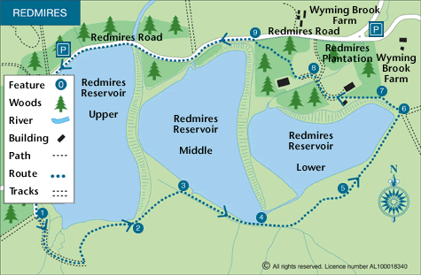
Redmires consists of three tiers of reservoirs. The route starts from the top and descends past each tier before completing a circuit by passing through pleasant woodland which can be seen across the water on the outward route. Located within the Peak District National Park many visitors mention the interesting shapes of reservoirs and often comment on the numbers of wildfowl and waders that can be seen here.
This is one of the free reservoir walks produced by Yorkshire Water who are one of the county's largest landowners, with around 72,000 acres of land spanning National Parks, Areas of Outstanding Natural Beauty, the North York Moors and the Yorkshire Wolds. There is a wide range of walks on offer from gentle strolls around one of their picturesque reservoirs to more adventurous routes. Yorkshire Water have selected some of their top walks for you and split them into three regional packs. Just print them out and off you go.
Each site has its own walk pack that you can easily print out and take along with you. Each pack includes directions to the site, a summary of the walk, a list of facilities available, a detailed route map and route instructions. To download walk descriptions go to Yorkshire Water Walks.
Messaging & Social Media
Message Walking Britain and follow the latest news.

Mountain Weather
Stay safe on the mountains with detailed weather forecasts - for iOS devices or for Android devices.