Walk 1583 - printer friendly version
Digley Reservoir Walk
Author - Yorkshire Water
Length - 5.0 miles / 8.1 km
Ascent - 600 feet / 182 metres
Grade - easy/mod
Start - OS grid reference SE110068
Lat 53.55771 + Long -1.8354194
Postcode HD9 2QD (approx. location only)
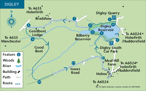
Located to the southwest of Holmfirth, this circular Peak District walk starts alongside Digley Reservoir and then continues along the shoreline before explore the surrounding countryside. Using a mixture of lanes, field paths and moorland routes the walk provides some excellent wide ranging views across the reservoir and surrounding countryside.
This is one of the free reservoir walks produced by Yorkshire Water who are one of the county's largest landowners, with around 72,000 acres of land spanning National Parks, Areas of Outstanding Natural Beauty, the North York Moors and the Yorkshire Wolds. There is a wide range of walks on offer from gentle strolls around one of their picturesque reservoirs to more adventurous routes. Yorkshire Water have selected some of their top walks for you and split them into three regional packs. Just print them out and off you go.
Each site has its own walk pack that you can easily print out and take along with you. Each pack includes directions to the site, a summary of the walk, a list of facilities available, a detailed route map and route instructions. To download walk descriptions go to Yorkshire Water Walks.
Messaging & Social Media
Message Walking Britain and follow the latest news.

Mountain Weather
Stay safe on the mountains with detailed weather forecasts - for iOS devices or for Android devices.