Walk 1587 - printer friendly version
Scammonden Reservoir Walk
Author - Yorkshire Water
Length - 4.0 miles / 6.5 km
Ascent - 150 feet / 45 metres
Grade - easy
Start - OS grid reference SE055164
Lat 53.644082 + Long -1.9182794
Postcode HD3 3FR (approx. location only)
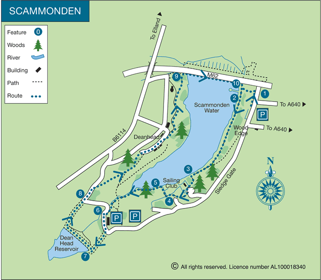
Scammonden Reservoir is located west of Huddersfield close to the A640. This walk includes a circuit of Scammonden Reservoir together with an optional diversion to nearby Deanhead Reservoir. The route follows unsurfaced paths which can be muddy after rain. The landscape is varied with sections of woodland and rough pastures. The views are generally good.
This is one of the free reservoir walks produced by Yorkshire Water who are one of the county's largest landowners, with around 72,000 acres of land spanning National Parks, Areas of Outstanding Natural Beauty, the North York Moors and the Yorkshire Wolds. There is a wide range of walks on offer from gentle strolls around one of their picturesque reservoirs to more adventurous routes. Yorkshire Water have selected some of their top walks for you and split them into three regional packs. Just print them out and off you go.
Each site has its own walk pack that you can easily print out and take along with you. Each pack includes directions to the site, a summary of the walk, a list of facilities available, a detailed route map and route instructions. To download walk descriptions go to Yorkshire Water Walks.
Messaging & Social Media
Message Walking Britain and follow the latest news.

Mountain Weather
Stay safe on the mountains with detailed weather forecasts - for iOS devices or for Android devices.