Walk 1598 - printer friendly version
Lud's Church, Back Forest & Clough Head Walk
Author - Lou Johnson
Length - 6.8 miles / 11.1 km
Ascent - 800 feet / 242 metres
Grade - easy/mod
Start - OS grid reference SJ998662
Lat 53.192886 + Long -2.00445
Postcode SK17 0SU (approx. location only)
The Roaches and surrounding country can be very busy of fine weekends especially on the western side of the ridge. This Peak District walk explores the 'quieter' side of the Staffordshire Roaches visiting the rocky cleft of Lud's Church before exploring the moorland and woodland of Back Forest and continuing via Clough Head back to the start.
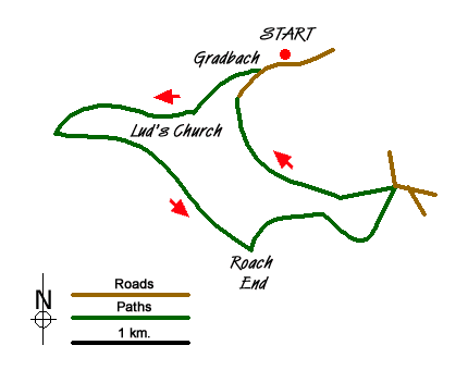
The start is a small car park beside the River Dane on the Staffordshire/Cheshire border close to the Youth Hostel at Gradbach. On busy days parking may be problematic so an early start is recommended. Exit the car park onto the lane and turn right. After 200 metres bear right down the access road to the Hostel, following the footpath signs through the property and alongside the river to reach a footbridge (grid ref. SJ990657).
Cross the footbridge. Ignore the paths either side along the river, instead climbing up amongst the trees to reach a cross path. Turn right towards Lud's Church. The path climbs gently through the woods. A signed diversion leads you to Lud's Church which is on your right. After exploring this rocky cleft, return to the path you have just left and continue to climb soon leaving the woods and entering open country.
The path is clear and improving views over the Dane Valley towards Cheshire soon emerge. The path swings left to reach a path junction (grid ref. SJ977655). Turn left here and follow a clear rising path across the moorland (Back Forest on OS maps). You get a superb view forward to the highest ground of the Roaches with its westerly facing crags dominant. The undulating path eventually descends to a road at Roach End (grid ref. SJ995644).
Here you have the option of climbing to the summit of the Roaches by taking the clear path ahead, which leads without any navigational problems to the summit trig point at 505 metres above sea level. The views are excellent on a clear day and worth the extra effort. This option will add an extra mile and 300 feet of ascent to the walk.
To continue from Roach End, turn left down the signed path which soon becomes a track and continue to descend past Moss End Farm (on your left) to reach a road junction (grid ref. SK008650). Turn sharp left along a walled track towards Cloughhead. The way ahead is never in doubt and after passing through a short section of rough country the path continues through a series of pastures with Gradbach Hill on your right. Continue along this path, passing through a farm onto a lane. Bear right and continue along this lane which leads back to the car park, which is on your right.
Messaging & Social Media
Message Walking Britain and follow the latest news.

Mountain Weather
Stay safe on the mountains with detailed weather forecasts - for iOS devices or for Android devices.