Hexton circular Walk
Walk 1625 - Route Maps
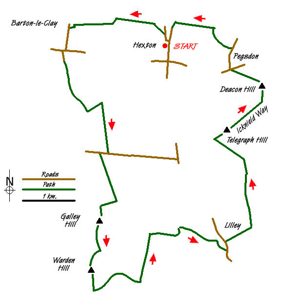
Route Map
Digital Maps - Copyright © 2011-2024. All rights reserved.
Sketch Map
Suggested Maps 

| Ordnance Survey Explorer 193 | Sheet Map | 1:25k | BUY |
| Anquet OS Explorer 193 | Digital Map | 1:25k | BUY |
| Ordnance Survey Landranger 166 | Sheet Map | 1:50k | BUY |
| Anquet OS Landranger 166 | Digital Map | 1:50k | BUY |
It is recommended you take a map. The preferred scale is 1:25k.
Start Point Details
Ordnance Survey Grid Ref TL106306
Latitude 51.962889 Longitude -0.391679
Postcode SG5 3JA
what3words start headliner.clasps.detection
Walk description may contain detailed information on the start point for this walk.
Further Information
Chilterns
The Chilterns lie only a few miles to the north west of London and yet they are a beautiful, unspoilt corner of England. The gently rolling hills are swathed in woodland and chalk downland and in quiet valleys attractive villages with their traditional brick and flint cottages nestle around medieval churches. The most dramatic feature of the area is the chalk escarpment, a ridge running south west to north east, which rises up steeply from the Vale of Aylesbury and slopes gently south east towards London. This underlying chalk geology gives rise to clear chalk streams which are home to valuable wildlife. Chilterns Walking Guide
Hertfordshire
Despite its proximity to London, Hertfordshire offers a wide range of walking opportunities through pleasant countryside and attractive villages. Hemel Hempstead, Stevenage, Watford and St Albans are the main towns with walks to suit all abilities within easy reach. The highest land in the county lies to the north-west at Pavis Wood near Tring (244 metres above sea level). Part of the county lies within the Chilterns National Landscape (formerly AONB) and is characterised by rolling hills offering scenic walks. Long distance footpaths in the county include the Ridgeway, Icknield Way, Harcamlow Way, Hertfordshire Way and the Grand Union Canal Walk.
Walk grading - Learn how each walk is assessed and select a walk to suit your ability and experience by going to Walk Grading Details.
Messaging & Social Media
Message Walking Britain and follow the latest news.

Mountain Weather
Stay safe on the mountains with detailed weather forecasts - for iOS devices or for Android devices.