Walk 1636 - printer friendly version
Danger Point & Ladram Bay from Otterton Walk
Author - Lou Johnson
Length - 6.0 miles / 9.8 km
Ascent - 500 feet / 152 metres
Grade - easy/mod
Start - OS grid reference SY080852
Lat 50.6591830 + Long -3.3029430
Postcode EX9 7JE (approx. location only)
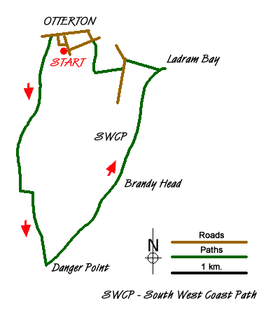
Starting from the village of Otterton, with its famous tearoom, the walk follows the banks of the River Otter towards the coast before turning northeast, using the South West Coast Path, along the sandstone cliffs typical of this part of Devon to Ladram Bay where there are a number of sandstone stacks.
The start is Otterton (grid ref. SY080852) where parking can be rather limited (see alternative start at the end of the description).Locate Fore Street and walk west crossing the bridge over the River Otter. Once over the river, turn left onto the footpath running south on the west bank of the River. Follow this path for just under one and a half miles until your reach a road a bridge over the river (grid ref. SY074830). Turn left over the bridge to the other side of the river and the right to follow the path. You are now on the South West Coast Path and this will be followed for the next section of the route.
Continue south to the mouth of the River Otter and the coast. The path turns north-east here and follows the cliff tops for about two miles passing a number of coastal features including Twopenny Loaf Rock! Reaching Chiselbury Bay, the coastal section is nearly complete and you should look out for the path junction (grid ref. SY094847) where you turn left to return to the centre of Otterton. However it is worth continuing along the coastal path for a few minutes to get a view over Ladram Bay with its wonderful rock stacks before returning to the path junction where you turn inland.
The path joins a track which leads to a lane (grid ref.SY089849). Turn left along the tarmac lane and then first right along Lea Lane (grid ref. SY0898470). Follow this track initially in a westerly direction before it turns sharp right and leads you into Otterton. Reaching the road with the interesting name of 'Behind Hayes', turn left into the centre of the village.
An alternative start is the car park at the east end of the seafront in Budleigh Salterton (grid ref. SY073819). From here take the South West Coast Path north along the River Otter to the bridge at grid ref. SY074830 mentioned in the description above. You can then follow the walk as described.
Messaging & Social Media
Message Walking Britain and follow the latest news.

Mountain Weather
Stay safe on the mountains with detailed weather forecasts - for iOS devices or for Android devices.