Cley next the Sea & Salthouse
Norfolk Walk
County/Area - Norfolk
Author - Lou Johnson
Length - 6.7 miles / 10.9 km Ascent - 150 feet / 45 metres
Time - 3 hours 30 minutes Grade - easy
Walk Route Description
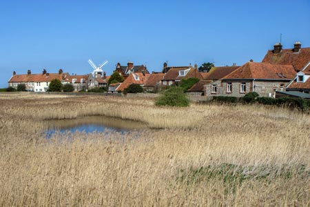
Click image to see photo description.
This easy walk along the Norfolk Coast offers an insight into this area. The start is the small car park behind the beach near Gramborough Hill (grid ref. TG081443). This can be reached off the main A149 coast road just east of the village of Salthouse. Refreshments are available in Cley next the Sea and also at Salthouse.
From the car park start walking west along the Norfolk Coast Path National Trail. The sea should be on your right. Continue along this path for just over 2 miles until you reach the car park (grid ref. TG048452) at the mouth of the River Glaven. Continue on the Norfolk Coast Path as it turns inland towards Cley next the Sea. Initially the path follows a road (on your left) and heads towards Cley Windmill. Reaching the main A140 road in Cley, turn left into the village.
Bear left following the A149 and stay with this main road past the Visitor Centre on your left. Reaching another car park (grid ref. TG059441) with a small copse opposite, continue along the main road locate a signed path on your right leading initially down a track. There is a small reservoir on your left as you join this track. After approximately 200 metres take the footpath on your left that leads across the Walsey Hills into the village of Salthouse.
Walk across the green to the A149 and continue east along the main road to the end of the village where you turn left down the road to the sea and the car park where you started.
Maps 

| Ordnance Survey Explorer 251 | Sheet Map | 1:25k | BUY |
| Anquet OS Explorer 251 | Digital Map | 1:25k | BUY |
| Ordnance Survey Digital Map Subscription | |||
| Latest Ordnance Survey Discounts | |||
Other walks nearby
| Walk 1730 | Blakeney Point | moderate | 9.0 miles |
| Walk 2401 | Salthouse from Cley-next-the-Sea | easy | 4.0 miles |
| Walk 1804 | Blakeney & Cley next the Sea | easy | 5.0 miles |
| Walk 1600 | Morston Salt Marshes from Morston Quay | easy | 2.5 miles |
| Walk 2307 | Blakeney from Morston Quay | easy | 2.0 miles |
| Walk 3732 | Morston, Blakeney & Cley next the Sea | easy | 4.0 miles |
| Walk 2653 | Sheringham to Cley-next-the-Sea | easy/mod | 8.5 miles |
| Walk 2151 | Metton & Felbrigg Hall | easy/mod | 6.2 miles |
| Walk 2081 | Holkham Gap and West Beach from Wells-next-the-Sea | easy | 4.0 miles |
| Walk 1908 | Wells-next-the-Sea & Holkham Park | easy/mod | 8.0 miles |
