Walk 1655 - printer friendly version
Downham & Pendle Hill (short version) Walk
Author - Lou Johnson
Length - 6.3 miles / 10.2 km
Ascent - 1400 feet / 424 metres
Grade - moderate
Start - OS grid reference SD785440
Lat 53.8917280 + Long -2.3286238
Postcode BB7 4BS (approx. location only)
This excellent Lancashire walk starts from the pretty village of Downham and ascends Pendle Hill. In good weather the views are extensive over the Ribble Valley to the Yorkshire Dales and the Southern Lake District, across Burnley to the Southern Pennines and across Clitheroe to the Trough of Bowland.
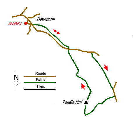
The car park (grid ref SD785440) marked on the OS map is not visibly signposted in the village. Assuming an approach from the Clitheroe / Chatburn side, descend the hill from the church, swing right over the bridge to cross Downham Beck then keep bearing right in to what appears to be a farm yard where the car park, public toilets and information centre are located. The free car park has space for about 25 cars but on nice days parking may be at a premium. There are also options for road side parking but do be considerate and respect the village residents right of access.
From the car park, return to the road at the side of Downham Beck where you will see two roads heading in an ESE/SE direction. Ignore the "main" road that you drove down and take the narrower of the two that runs alongside the right hand bank of Downham Beck, passing some picturesque cottages, a number of which have their own private bridges across the beck. At the end of the cottages, pass through the gate in to the field and follow the waymarked footpath. This initially tracks alongside the beck before veering away gradually to the right. About 170m after starting to veer away from the beck, the footpath forks. At this point take the right hand path, heading SE and almost parallel to Pendle Road. The way ahead is reasonably obvious as far as the stile over the wall part way up a gentle incline (grid ref SD796434). From the stile, note the small barn ahead and aim for the left hand side of the barn where there is a step stile built in to the wall. On emerging on to Pendle Road (grid ref. SD798432), turn left up the lane. Across the road is the concessionary path which you will use for the descent.
Continue up the lane for about half a mile until you reach a small wood on your right (grid ref. SD806431). Turn right here following the path initially through the wood and then out into open country. Follow this clear path until you reach Barley Lane (grid ref. SD813418). Continue ahead on this road to take the track on your left at grid ref. SD814416. Follow this track west passing Pendle Side on your left to reach a footpath on your right. Take this path and walk a short way to bear left alongside a wall (which is on your left) and follow the clear path as it makes a loop across the side of Pendle Hill to gain the summit.
To return to the start descend using the concessionary path that descends across the northern slopes back to Downham village. The path shown on OS maps is inaccurately drawn and you should instead follow the clear path evident on the ground. The path leads down to the lane at grid ref. SD798432. Cross the road and follow the path used for the outward route back to the start.
Messaging & Social Media
Message Walking Britain and follow the latest news.

Mountain Weather
Stay safe on the mountains with detailed weather forecasts - for iOS devices or for Android devices.