Walk 1656 - printer friendly version
Thorney Island circular from Prinsted Walk
Author - Lou Johnson
Length - 9.0 miles / 14.6 km
Ascent - 100 feet / 30 metres
Grade - easy/mod
Start - OS grid reference SU765050
Lat 50.8394810 + Long -0.9149161
Postcode PO10 8HS (approx. location only)
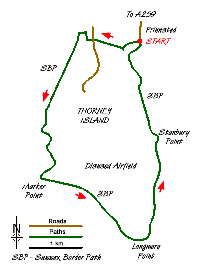
This route follows the shoreline of Chichester Harbour around Thorney Island. There are good views across the harbour. The start is the small free car park at Prinsted just off the A259 (grid ref. SU765050). It is important that you consult tide times as the route may be flooded in one or two places at very high spring tides. Parts of Thorney Island is Ministry of Defence land so short cuts across Thorney Island are not permitted.
From the car park follow the track west. Take the footpath on your right passing Thornham Farm on your left with the path soon becoming a track again. You are now on the Sussex Border Path and will follow it for most of the route. Reaching a road, cross straight over and continue on the path ahead. Reaching a T-junction with a track, turn right (grid ref. SU755501). The walk briefly heads north. Take the path on your left at grid ref. SU755052) to pass the southern end of a marina. You soon reach the shoreline.
Turn left along the shore and follow it back to the start! Initially you have views across the Emsworth Channel to Hayling Island. You pass Wickor and Marker Points before the path turns towards the southeast with views now to Chichester Harbour. Reaching Longmere Point (the most southerly point on the island) you will see Pilsey Island just offshore with West Wittering on the shore at the far side the water. Turning north you have Thorney Channel on your right. Passing the Church and War Cemetery you continue north to Stanbury Point and back to the start.
Note In the past access to this area has been strictly controlled with guards at the entry and exit points to MOD property. Access to the Church and adjacent cemetery has also be restricted. However this situation has recently changed so the advice is to read and obey any signs detailing access to the site.
Messaging & Social Media
Message Walking Britain and follow the latest news.

Mountain Weather
Stay safe on the mountains with detailed weather forecasts - for iOS devices or for Android devices.