Walk 1665 - printer friendly version
Hollins Cross & Lose Hill Walk
Author - Lou Johnson
Length - 6.0 miles / 9.8 km
Ascent - 1100 feet / 333 metres
Grade - easy/mod
Start - OS grid reference SK149829
Lat 53.3427910 + Long -1.7776702
Postcode S33 8WN (approx. location only)
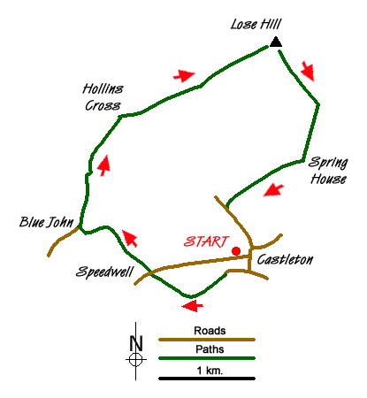
This Peak District walk includes a section of the Great Ridge to the north of Castleton. The route also passes a number of the show caves in the area that are famous for Blue John Crystal. The start is the village of Castleton, which is a popular spot for tourists. There is a large pay and display car park adjacent to the Tourism Information Centre at grid ref. SK149829. There are plenty of opportunities for refreshment in the village either before you start the walk or after you have returned.
Exit the car park and turn left along Buxton Road and walk as far as the T-junction. Turn right here along Back Street which leads to the Market Place. Here bear right and continue along The Stones which leads directly into Goosehill. Towards the end of this lane take the signed footpath (grid ref. SK147826) bearing right towards Speedwell Cavern with the wall to your immediate right. This path climbs gently offering good views to your right of the Castleton Ridge which you will be walking shortly.
Reaching the road by Speedwell Cavern (grid ref. SK139827), take the footpath almost opposite (just to your right). This leads through a field to a junction of paths (not too evident) where you keep straight on climbing steadily above Treak Cliff Cavern to reach Blue John Cavern at the top of the climb where you turn right down the access road. Reaching the 'main' road, turn right. Almost immediately you will encounter the remains of the major landslip beneath Mam Tor which has severed the main road. Continue along this old road until it turns sharp right. On the bend there is a minor lane leading to Mam Farm. Just to the left of this lane, is a path (marked on OS maps) that leads across the hillside towards Hollins Cross. Follow this until you reach the ridge with its prominent toposcope.
Once on the ridge bear right and continue along what can be a very busy path. Reaching the climb up to Back Tor (grid ref. SK144848), keep left and continue to the trip point on Lose Hill. The views on both sides are excellent with the valley containing Castleton to your right and the rough moorland of Kinder Scout to your left.
The descent starts here and your first objective is Lose Hill Farm, which lies to the south. Approaching the farm, keep left and continue down to Spring House Farm. Turn right here and using a mix of tracks and paths continue west to reach Hollowford Road (grid ref. SK147834). Turn left down the lane and you will soon be back in Castleton.
Messaging & Social Media
Message Walking Britain and follow the latest news.

Mountain Weather
Stay safe on the mountains with detailed weather forecasts - for iOS devices or for Android devices.