Walk 1674 - printer friendly version
Rosedale Valley circular from Little Blakey Walk
Author - Andy Chaplin
Length - 11.0 miles / 17.9 km
Ascent - 1000 feet / 303 metres
Grade - moderate
Start - OS grid reference SE684990
Lat 54.3819110 + Long -0.9483695
Postcode YO62 7LQ (approx. location only)
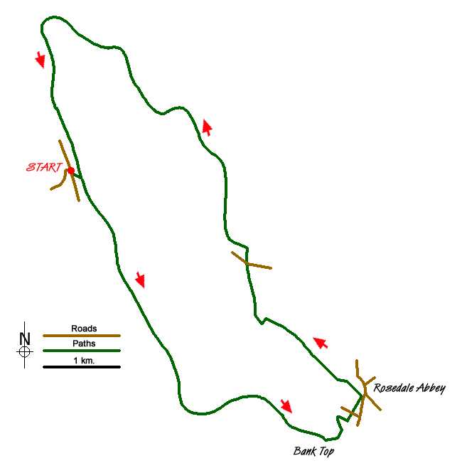
This North York Moors walk has that great combination of fantastic views, relatively easy walking and fascinating industrial history. Oh yes, and it starts near to the Lion Inn at Blakey on the C2C route. Park at Little Blakey (grid ref. SE684990) where the dismantled railway from Battersby Junction/incline crosses the Blakey Road. There are information boards here about the railway and the mine working heritage.
After parking, take the path down to the old railway, turn right and follow the route all the way to Bank Top (grid ref. SE719951). There are great views into the Rosedale valley and over to the old mine buildings. After 3.75 miles, and just before the house at Bank Top, follow the track off towards the house then bear off left downhill across the open land towards the corner of a wall/pen and then more steeply downhill through bracken. Continue right along a wall and then turn right over a stile into the golf course. The path is signed to turn left around reception and out onto Daleside Road (grid ref. SE722954).
Take the path directly across the road into Rosedale, coming out onto Gill Lane just before the bridge over the River Seven through a passageway alongside a house. Go left into the village and keep left at the junction in front of the Abbey Stores taking the road past the old school. Take either the first or second path either side of a house and go through to the campsite. Then follow the road and footpath which is signposted to Dunn Carr bridge. At the River Seven take the middle path over board steps, not crossing the river nor going uphill on the right.
Follow the path across fields then left down a farm track and follow the River Seven again on your left until you get to another bridge. Once again do not cross the bridge but go off on a part-hidden stone path leading north-west across a field. The path crosses a couple of fields and eventually becomes a track leading out at Hill Houses on Alders Road.
Cross over and take the track up past the farm. Then keep left until you pick up the old railway again, which runs along the edge of the valley. The path is easy to follow all the way back to Blakey and gives plenty of opportunities to admire the view and read the information boards at the old mine workings.
Messaging & Social Media
Message Walking Britain and follow the latest news.

Mountain Weather
Stay safe on the mountains with detailed weather forecasts - for iOS devices or for Android devices.