Walk 1676 - printer friendly version
Ullock Pike, Long Side and Carl Side Walk
Author - Lou Johnson
Length - 5.5 miles / 8.9 km
Ascent - 2450 feet / 742 metres
Grade - moderate
Start - OS grid reference NY236310
Lat 54.668259 + Long -3.1860949
Postcode CA12 4QY (approx. location only)
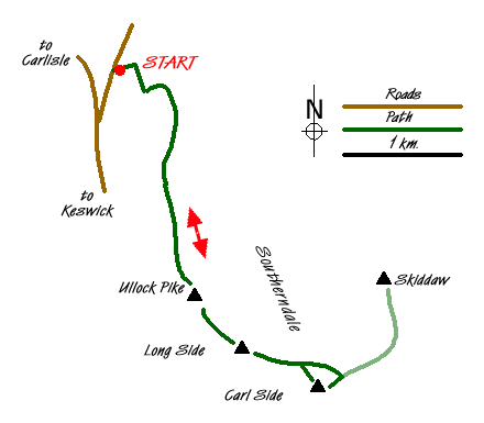
Ullock Pike, Long Side and Carl Side are three Wainwrights connected by a high ridge that is located on the south-western aspect of Skiddaw. The views south over Lake Bassenthwaite, the north-western fells, Keswick and Derwentwater are good and provide ample reason for completing this straightforward out and back excursion along the ridge.
The start of this Lake District walk is the small car park (Grid ref. NY236310) near High Side a short way along the narrow lane leading from the A591 just north of the Ravenstone Hotel to Orthwaite. After parking go through the gate adjacent to the parking area and follow the bridleway northeast towards Barkbeth. Turn right a short way along this track at a marker post and follow the obvious path uphill. Bear right through the gate on your left and continue to climb along an excellent greenway into Southerndale. Stay on this track passing the ford on your left (Grid ref NY242304) with a wonderful ahead towards Skiddaw and the ridge about to be ascended.
The path then leaves the valley and climbs to the col between The Watches and Ling How. Here you turn left and start the climb up the ridge. The path is clear and the going good and progress uphill is fairly rapid. As you climb higher there is one section over rock below the summit of Ullock Pike that needs more care before the path continues to the cairn. Looking ahead you can see the onward route, which follows the ridge. Continuing over Long Side, stay on the main path to Carl Side Tarn (Little evidence of this on the ground). Here turn sharp right on a broad path to the summit of Carl Side from where excellent views over Derwentwater maybe enjoyed.
The return route generally follows the outward route. However there are two recommended modifications. First take the direct path to Long Side from Carl Side summit. This cuts across grass and avoids the need to retrace your steps to the non-existent Tarn. Continue over Long Side and Ullock Pike as in the outward route. Reaching the col after Long How, continue ahead down the ridge to reach a wall. Turn right and follow the path down to the track in Southerndale used on the outward walk. Turn left and retrace your steps back to the start.
Messaging & Social Media
Message Walking Britain and follow the latest news.

Mountain Weather
Stay safe on the mountains with detailed weather forecasts - for iOS devices or for Android devices.