Walk 1678 - printer friendly version
Bleak House & Great Nodden from Lydford Walk
Author - Lou Johnson
Length - 7.5 miles / 12.2 km
Ascent - 1000 feet / 303 metres
Grade - easy/mod
Start - OS grid reference SX525853
Lat 50.6486610 + Long -4.0877242
Postcode EX20 4AZ (approx. location only)
Dartmoor offers some wild country for walking and this route takes you into this environment passing a number of the typical rocky summits known as 'Tors'. The route needs careful navigation and an OS 1:25000 map is very helpful especially for the section around Bleak House. Like all upland areas weather can change dramatically so do make sure you have adequate footwear, clothing and refreshments.
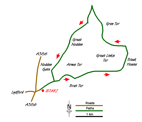
The start is the small car park just off the A386 at grid ref. SX525853. This is reached by going east along a narrow lane from the Dartmoor Inn on the A386, near Lydford. After parking take the well trodden path leading northeast to a ford, footbridge and stepping stones across the River Lyd (grid ref. SX531857). Ahead to the right is Brat Tor with its stone cross whilst to the left is the rocky outcrop of Arms Tor. The onward route leads between these two tors on a rising path/bridleway across the moors. The path continues to climb across the southern flank of Great Links Tor. Continue along the path/track following it as it turns north to pass the ruin of Bleak House (grid ref. SX559865) on your right. This house was the residence of the Manager responsible for the peat cutting operations in this area.
The onward path crosses Rattle Brook a short distance past Bleak House and continues alongside the stream for a further 600 yards to meet a clear track at grid ref. SX559871. Turn left and follows this track west crossing a small embankment and continue through a shallow cutting. You are now on the former track bed of the Rattlestone Peat Railway and its route will be followed for most of the way back to the start. The route is clear on the ground as the old railway heads north passing the Logan Stone on your right (grid ref. SX550879). Continue north descending gently to reach the former turning point for the railway at grid ref. SX545887.
Turn sharp left here and walk south on the old track bed as it descends across the western flank of Great Nodden (on your left) to approach Nodden Gate. Aim for the wall corner (grid ref. SX532863) and then walk south on the west bank of River Lyd to reach the river crossing passed on the outward route. Here, turn right along the wall and follow the clear track back to the car park.
Messaging & Social Media
Message Walking Britain and follow the latest news.

Mountain Weather
Stay safe on the mountains with detailed weather forecasts - for iOS devices or for Android devices.