Walk 1687 - printer friendly version
Broomhead & Howden Moors Walk
Author - Andy Chaplin
Length - 12.4 miles / 20.2 km
Ascent - 1470 feet / 445 metres
Grade - moderate
Start - OS grid reference SK246945
Lat 53.4466970 + Long -1.6310826
Postcode S6 6JN (approx. location only)
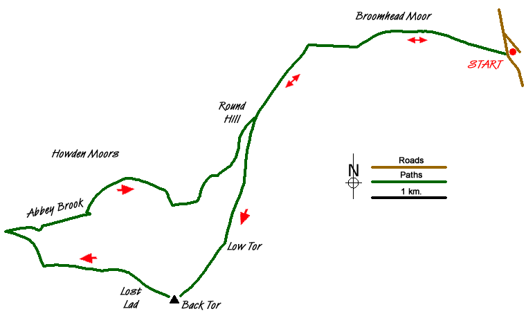
This Peak District walk starts from the same place as Walk 1522 and uses the Dukes Road path in order to get to Back Tor and Lost Lad but then comes back up the Abbey Brook valley to Howden Moor. This part of the walk is also included in Walk 1219 but in this circuit you get all of the Abbey Brook valley. This valley is particularly impressive and feels quite remote - considering how close it is to the thousands of people that are circuiting around Ladybower.
From the roadside parking at grid ref. SK246945 on Mortimer Road take the moors track through the gate onto the Fitzwilliam (Wentworth) Estate on the Dukes Road to Flint Hill. As you get to the top of the hill the path gets to be less of a track and more boggy - but still reasonably easy walking. As you start to descend slightly towards Cartledge Flat the path becomes paved as it crosses Hobson Moss until just before the rocks at Cartledge Bents.
The two main paths leading southwards from Cartledge Bents merge again shortly after the rocks and the path becomes paved again all the way to just below the trig point at Back Tor. Turn right below the rocks and follow the path to Lost Lad then continue straight on past the orientation table below Lost Lad Hillend.
Continue westwards on moors tracks and paths across Greystones Moss, cross a stream (grid ref. SK180915) and continue up the far side from the stream to the fence. Turn right after the gate and follow the track along the fence and then down to the Abbey Tip Plantation just before the Upper Derwent Reservoir.
At the National Trust's Little Howden Moor sign turn back on the track that leads up alongside the Abbey Brook. After a track leads off to the right up Sheepfold Clough to Lost Lad, the Abbey Brook path follows the steep valley side around Berristers Tor and over Bents Clough. There are some fine views back along the valley and up Foul Clough and Crook Clough on either side of Berristers Tor. For those that are not keen on paths that cling to the valley side it is always possible to walk further up on top of the Cartledge Bents valley side.
When the path reaches the top of the valley the most visible route seems to be eastwards towards the two sets of rocks that are visible on Cartledge Bents. On the map the path is shown heading north east along the brook side but this is fairly difficult to find. Heading eastwards across Cartledge Bents means you soon come to the second set of rocks which mark the start of the paved path back to the Dukes Road. In all it is another 3 miles back to the parking on Mortimer Road with views this time back towards Bradfield.
Messaging & Social Media
Message Walking Britain and follow the latest news.

Mountain Weather
Stay safe on the mountains with detailed weather forecasts - for iOS devices or for Android devices.