Walk 1688 - printer friendly version
Old Dam & Sparrowpit from Mam Nick Walk
Author - Andy Chaplin
Length - 9.0 miles / 14.6 km
Ascent - 1125 feet / 341 metres
Grade - moderate
Start - OS grid reference SK129832
Lat 53.3455400 + Long -1.8076971
Postcode S33 8WA (approx. location only)
With the obvious attractions of the Edale loop, the countryside to the south is less dramatic but worth a look. This Peak District walk covers the limestone moors and dales to the west of Winnats pass and takes in part of the Limestone Way and Pennine Bridleway.
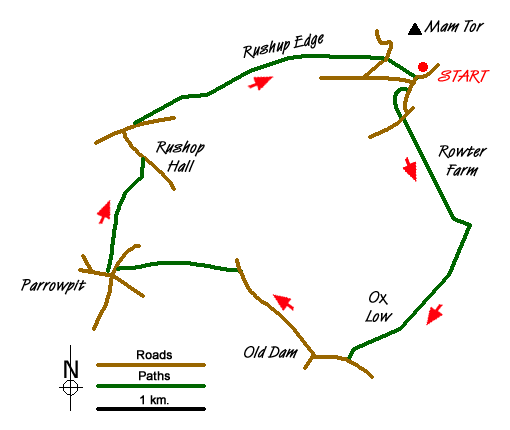
After parking on the old road below Mam Tor (grid ref. SK129832), take the road south and continue on the path across Windy Knoll. Cross straight over the road (grid ref. SK126826) and take the track up past Rowter Farm. As you pass the farm there are some good views behind you to Mam Tor. Carry on along the track then turn left at the end onto another limestone track. When this meets the Limestone Way at the next gate (grid ref. SK135812), turn right over Old Moor and follow the Limestone Way for 500 metres.
Take the bridleway that goes off on your right through the gate in the wall (grid ref. SK132806). Follow this as it becomes a track and leads past Oxlow Rake to Woodside Farm and Oxlow End. Turn left on the road down to Old Dam Road then right along the road into Old Dam.
Take the road straight on out of the village which leads up Perry Dale and is part of the Pennine Bridleway. Before you get to Perryfoot turn left up into the wood and take the path that follows an old lead mining rake vein up the hillside below Gautries Hill and the old Coalpit Hole lead mine.
Continue across the fields to Sparrowpit and come out onto the road through the Memorial Hall car park. Turn left towards the Wanted Inn (worth a detour at the end of the walk) then off right through the farmyard, just before the road to Blackbrook, on a path signed to Rushup & Castleton. Pass Rushup Farm and head on across the fields to Rushop Hall.
As you climb up the northern side of the Rushop valley you have good views back into it - an odd little valley bowl surrounded on all sides by the hills that overlook the much more impressive Edale, Hope, and Chapel-en-le-Frith valleys. Turn left on the road in front of Rushop Hall then at the road junction at the top, cross over and take the path that runs alongside the road and leads up to Lords Seat. You now have the views down into the Edale valley.
Continue along towards Mam Tor then cross the "Mam Nick" road and take the path over the field downhill to the parking.
Messaging & Social Media
Message Walking Britain and follow the latest news.

Mountain Weather
Stay safe on the mountains with detailed weather forecasts - for iOS devices or for Android devices.