Walk 1694 - printer friendly version
Nappa Hall & Whitfield Gill Force Walk
Author - Lou Johnson
Length - 6.0 miles / 9.8 km
Ascent - 750 feet / 227 metres
Grade - easy/mod
Start - OS grid reference SD950911
Lat 54.315464 + Long -2.0783612
Postcode DL8 3HJ (approx. location only)
Wensleydale offers some wonderful walking with the River Ure never too far away. The scenery is the valley is green and verdant with stone walls criss-crossing the landscape. On either side of the valley the land rises with some outcrops of limestone adding interest to the scenery.
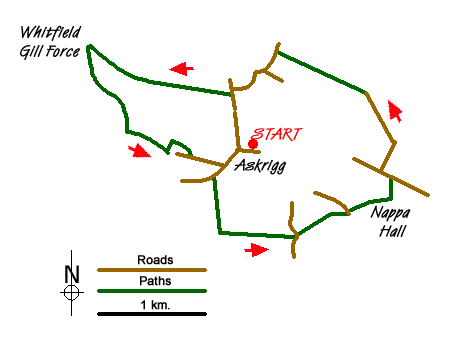
This Yorkshire Dales walk starts in the village of Askrigg where a small car park is located at grid ref. SD950911. After parking, exit the car park and turn right into the centre of the village bearing left along the road to Bainbridge and Hawes. Continue past St. Oswald's church on your left and just after the road bends to the right, take the public footpath on your left. Initially a track the path crosses the old railway and continues across the flood plain to the River Ure. Do not cross the river, instead bear left and follow the River Ure to Worton Bridge where you join a lane. Do not cross the river but continue ahead to leave the lane using a footpath on your right. This continues to follow the river to Nappa Mill where you turn left away from the river to re-cross the old railway.
Here bear half left across two fields towards Nappa Hall. Bear left along a track and continue through the hall to reach a lane (grid ref. SD965908). Go left here and then take the first lane on your right. The lane - Harr Gill - climbs steadily offering some fine views ahead to Ellerkin Scar to reach Heugh. Bearing left join the track that heads straight across the lower slopes of Newbiggin Pasture to reach a lane (grid ref. SD953921). Turn left downhill. At the first junction keep straight ahead. Ignore a track on your right and continue down the lane to another junction (grid ref. SD949917). Turn left and almost immediately right onto a walled track (Low Straights Lane). Follow this track for a mile to reach a gate that is the end of the walled lane.
Turn left onto the signed footpath which leads above Whitfield Gill which is down on your left. Continue by following the path across the gill. Turn left downstream shadowing the gill. Ignore paths to your left and right and stay with the stream down to a pretty waterfall (grid ref. SD938914). Continue downstream to a footbridge on your left. Cross this and turn right. This path leads onto a lane (grid ref. SD944911). Bear left along this lane which leads into Askrigg. Reaching the main street through the village, turn left to return to the start.
Messaging & Social Media
Message Walking Britain and follow the latest news.

Mountain Weather
Stay safe on the mountains with detailed weather forecasts - for iOS devices or for Android devices.