Walk 1696 - printer friendly version
Weacombe Combe, Bicknoller Post, Kilve & Longstone Hill Walk
Author - Philip Churchyard
Length - 7.5 miles / 12.2 km
Ascent - 1200 feet / 364 metres
Grade - easy/mod
Start - OS grid reference ST116410
Lat 51.161395 + Long -3.2655605
Postcode TA4 4EB (approx. location only)
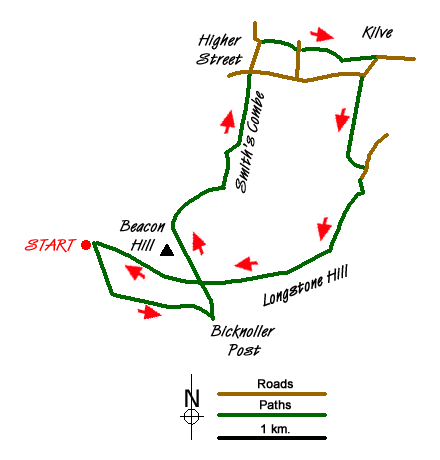
From the Staple Plain car park (grid. Ref ST116410) take the path running south west downhill. At the bottom turn sharp left to follow the stream running largely eastward along Weacombe Combe climbing steadily. the path crosses the stream several times, eventually running above the stream which is now in a small ravine on the left. Very quickly you come out of the woodland and into typical Quantock scenery of grassland with Pine, gorse bracken and bilberry. At the top, at Bicknoller Post, take the main path to the left running north and then north west crossing the Great Road and with the trig point of Beacon Hill on your left. In front are good views over the Bristol Channel to South Wales.
Once past Beacon Hill take a turning on the right to run north east (there is a wooden sign post labelled Smith's Combe) and follow the path steeply down hill (when in the shadow of the small copse the path becomes slippery) picking up a small stream at the bottom as the path turns north into Smith's Combe and into Pine woodland.
Eventually the path crosses the Quantock Greenpath and emerges into pastureland. Keep walking northwards across the field and go through the hedge into a green lane which ends at the A39, Higher Street, Kilve. Cross the A39, but take care as the road is fast and busy, and into the metalled lane opposite.
Follow this lane past the cottages on the left until you reach a sharp left turn. Here take the gate through the hedge and follow the footpath eastwards, crossing two fields, and coming into Frog Street. Across Frog Street and slightly to the right is another footpath. Follow this with the cottages on your left cross the field, go through the hedge and take the path south east, through the next hedge and cross the third field (shown following a field boundary on the map, but in reality this boundary has long gone), through the next hedge and to the gate leading back onto the A39.
Cross the road and go through the gate in the opposite hedge (ignore the notice about access - this is out of date). Here you have a choice. Turning left will take you into the village of Kilve and the Hood Arms, which is a real ale pub with a sunny beer garden shielded from the main road and very dog friendly.
Turn right and follow the main road to the next corner, but screened from the road by the hedge. If you detour to the Hood Arms you'll need to retrace your steps and then pick up the path here. At Winrush corner leave the main road and follow the track south, which is metalled so watch out for occasional cars, up hill to the bungalows. At the end of the track take the footpath south east across one field and then east across the second to come into Pardlestone Lane. Follow the lane south west to the end, and then take the track through the gate on your right which skirts round some houses. At the other side of the houses take the left hand path past the No Vehicles sign and through the wooden gate and back onto the moorland gradually climbing towards the top of Longstone Hill.
When the path meets the Great Road, follow it westwards back towards Beacon Hill. Do not climb Beacon Hill, but continue to follow the Great Road back down hill to Staple Plain car park with views in front of you of Minehead and Exmoor.
Messaging & Social Media
Message Walking Britain and follow the latest news.

Mountain Weather
Stay safe on the mountains with detailed weather forecasts - for iOS devices or for Android devices.