Walk 1710 - printer friendly version
Glenridding, St. Sunday Crag & Helvellyn Walk
Author - Lou Johnson
Length - 11.5 miles / 18.7 km
Ascent - 4800 feet / 1455 metres
Grade - hard
Start - OS grid reference NY386169
Lat 54.543618 + Long -2.9506035
Postcode CA11 0PD (approx. location only)
The Eastern Fells are dominated by Helvellyn, the third highest mountain in the Lake District and England, and partly as a result of this the area is very busy. This walk is demanding and involves a considerable amount of uphill walking but the rewards are ample with St Sunday Crag, Fairfield and the other summits all worthy of an ascent in their own right.
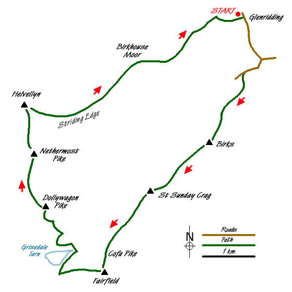
The route starts from Glenridding (Grid ref. NY386169) where there are a number of options for parking. The village also has a variety of pubs, cafes and shops. From Glenridding, walk south along the main road towards Patterdale. On one section you get a good view across Ullswater to Place Fell on the other side of the lake. Immediately after Grisedale Beck (Grid ref. NY390161) turn right up the lane in Grisedale. Continue up the valley to grid ref.NY386158 where you take the signed path through the gate on your left that leads onto St Sunday Crag. The ascent begins immediately taking you up to Thornhow End from where the ascent becomes less steep.
In clear weather the path over Birks is better otherwise you can skirt the summit. To include Birks you need to make an early decision after passing Thornhow End where you take fork left. The advantage of including Birks is that you get a grandstand view over Ullswater and Place Fell. In addition you are able to inspect the route ahead and soon realise that St Sunday Crag is a big fell. Dropping slightly to a col, the path continues to ascend steeply with the subsidiary summit of Gavel Pike on your right. As the slope finally eases you arrive at the summit area. Due to its isolated location the view is extensive and it is worth taking some time to identify the various hills that surround you.
Continuing, there is a long descent to Deepdale Hause (Grid ref. NY359124) before the steep ascent over Cofa Pike onto Fairfield. I found the latter summit to be rather disappointing on my first visit, but since I have discovered that by walking a little you can improve the views substantially especially east over Hart Crag and Hartsop above How to High Street. Care is now needed to ensure that the correct path is used for descent from Fairfield. Head just north of east from the summit cairn and locate the cairn marking the descent path to Grisedale Tarn. In places this descent is a little rough underfoot although the immediate surroundings help diminish the discomfort. Reaching Hause Gap (Grid ref. NY349117) bear right and follow the path along the eastern shore of Grisedale Tarn.
Cross Grisedale Beck and at the path junction bear left and start the sinuous ascent of Dollywaggon Pike. This climb is tedious but once completed you have finished most of the walk's ascent. The main path bypasses the summit of Dollywaggon Pike (Grid ref. NY346130) but the short diversion is worth the extra effort with an excellent view down Grisedale and across to St Sunday Crag. Continue on the main path towards Helvellyn taking in the intermediate summit of Nethermost Pike from where you get a great view of Striding Edge.
A short descent followed by another featureless ascent brings you to Helvellyn's summit where a few minutes exploration are worthwhile. The next important navigational decision is choosing the right spot to descend steeply to the western end of Striding Edge. From the main cairn walk southeast and near the Gough Memorial begin to descend. The descent is eroded with numerous paths and care is needed before reaching the foot of the bad step on Striding Edge. The edge itself has many paths and you can one that most suits your abilities.
All the major objectives of the walk have now been completed and your descent along Striding Edge continues to the Hole in the Wall (Grid ref. NY359155). Do not go through the gate; instead follow the wall keeping it on your immediate right as you descend onto Birkhouse Moor. The way ahead is clear with the path running parallel to the wall before dropping into Little Cove. Cross Mires Beck on a footbridge and continue down to Rattlebeck Bridge. From here it is probably easier to stay on the south side of Glenridding Beck for the short walk back to the start.
Messaging & Social Media
Message Walking Britain and follow the latest news.

Mountain Weather
Stay safe on the mountains with detailed weather forecasts - for iOS devices or for Android devices.