Walk 1728 - printer friendly version
Axe Edge Moor & Three Shires Head Walk
Author - Lou Johnson
Length - 7.2 miles / 11.7 km
Ascent - 1000 feet / 303 metres
Grade - easy/mod
Start - OS grid reference SK018715
Lat 53.2405240 + Long -1.9744876
Postcode SK17 6TT (approx. location only)
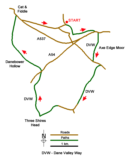
This Peak District walk starts from the Derbyshire Bridge carpark just north of the A537 Buxton to Macclesfield road (grid ref. SK018715). The route explores the wild moorland of Axe Edge and visits Three Shires Head where the counties of Staffordshire, Cheshire and Derbyshire meet. The walk is mostly easy to follow as it uses parts of the Dane Valley Way which is well waymarked. However, it is recommended you do take a copy of the relevant OS 1;25000 map as this will help navigation at several key points along the way.
From the car park, walk east initially along a tarmac road to join a track. This soon becomes a path which climbs gently over rough ground to reach a T-junction with a track (grid ref. SK020712). Turn left and follow this track until it nears the A537. Bear left to the A537 and then turn left along the main road for about 100 metres. Here (grid ref. SK028713) cross the road with extreme care and walk south on the Dane Valley Way. This path across Axe Edge Moor can be muddy after wet weather but progress is usually good as you climb to the road at Dane Head (grid ref. SK026703).
Turn left along the road until you reach a rough track on the right (grid ref. SK029702). This is the continuation of the Dane Valley Way. Follow this initially almost level track over rough moorland. The track then descends with the flanks of Drystone Edge on your left. Reaching the lane below Orchard Farm (grid ref. SK021687) keep straight ahead on the tarmac lane. Ignore the lane leading off to the left and continue straight ahead. Ignore the Dane Valley Way sign leading uphill across a field on your right and continue to the end of the tarmac lane (grid ref. SK015688).
The tarmac lane leads into a rougher stony track that leads down to a picturesque bridge over the River Dane at Three Shires Head (grid ref. SK009685). Cross the bridge and immediately turn right. You have re-joined the Dane Way and this is followed north with the River Dane on your right. Stay with the riverside path ignoring paths on the left and continue up to the A54 at Danebower.
Take care crossing this road and pick up the path opposite. This path leads up Danebower Hollow climbing steadily through rough moorland to meet the A537 at the Cat & Fiddle Pub. Cross the road which often has fast traffic and walk right along this main road using the grassy verge. You soon reach a tarmac lane (grid ref. SK003717) which is followed back to the car park at Derbyshire Bridge.
Messaging & Social Media
Message Walking Britain and follow the latest news.

Mountain Weather
Stay safe on the mountains with detailed weather forecasts - for iOS devices or for Android devices.