Walk 1733 - printer friendly version
Wessex Downs & Kennet & Avon Canal from Pewsey Walk
Author - Lou Johnson
Length - 8.0 miles / 13 km
Ascent - 950 feet / 288 metres
Grade - easy/mod
Start - OS grid reference SU158610
Lat 51.3478640 + Long -1.7745237
Postcode SN9 5NT (approx. location only)
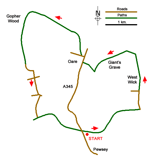
This Wiltshire walk includes a section of the Kennet & Avon canal in the Vale of Pewsey and the rolling hills of the North Wessex Downs. The route follows waymarked paths including sections of the White Horse Trail, Mid Wilts Way and the Tan Hill Way long distance trails. The start of the walk is Pewsey Wharf, just off the A345 Pewsey to Marlborough road, where parking is available (grid ref. SU158610).
Walk east along the canal towpath (canal on your left) and continue to bridge 112. Just before the bridge leave the towpath by turning right up to a lane. Turn left and walk north towards the Downs. At the first road junction (grid ref. SU174621) go straight ahead towards West Wick. The lane becomes a track and you continue north to reach the foot of the escarpment (grid ref. SU176633). Once through the gate bear left climbing steeply to reach the top of the downs. Turn left onto the White Horse Trail following the clear path passing the trig point on Oare Hill before descending to a track (grid ref SU161628). Turn right along this track and walk into the village of Oare and the A345.
Turn right along the A345 through the village for 200 metres before turning first left along a lane passing the school on your left. Just past a row of cottages on the right, turn right onto a footpath (grid ref. SU157632) to follow the Mid Wilts Way to the foot of the escarpment. Another steep climb leads past a seat to a gate on the hilltop. Walk along the enclosed path to reach a driveway (grid ref. SU156640). Turn left along the drive keeping straight ahead where the drive bears left after 20 metres or so. This path leads through woods onto the open downs.
Continue following the White Horse Trail (and Tan Hill Way) to the junction of paths and tracks just northeast of Gopher Wood (grid ref. SU142645). Careful navigation is required here and you should take the path/bridleway into Gopher Wood. After 400 metres or so the path exits the wood at a gate. Continue south downhill into the Vale of Pewsey. Reaching a lane (grid ref. SU141630) continue straight ahead passing Draycott Farm to a crossroads (grid ref. SU144626).
Go straight across this junction. After a further 450 metres you reach the first of two lanes on the right. Ignore the first lane but take the second right turn (grid ref. SU145621). This lane leads down to the Kennet & Avon canal (grid ref. SU144614). Go through the hedge to join the towpath. Turn left (with the canal on your right). Reaching Bristow Bridge the towpath crosses to the other bank and soon leads back to the start at Pewsey Wharf.
Messaging & Social Media
Message Walking Britain and follow the latest news.

Mountain Weather
Stay safe on the mountains with detailed weather forecasts - for iOS devices or for Android devices.