Walk 1739 - printer friendly version
Crinkle Crags and Bowfell (Oxendale Horseshoe) Walk
Author - Lou Johnson
Length - 7.8 miles / 12.7 km
Ascent - 3200 feet / 970 metres
Grade - hard
Start - OS grid reference NY286060
Lat 54.4443650 + Long -3.1025093
Postcode LA22 9JY (approx. location only)
The summits of the Crinkle Crags and Bowfell have always been popular objectives for walkers in the Lake District. This route follows a circuit of rugged Oxendale to reach the summits following the path above Browney Gill to reach the high ground below Cold Pike. From here the route heads west passing the minor top of Great Knott to reach Crinkle Crags with their five craggy tops. The route then descends to Three Tarns before ascending magnificent Bowfell with its superb views. The return route follows the Band offering a wonderful panorama of Great Langdale and its surrounding fells.
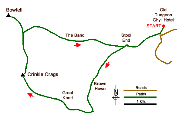
The start of this Lake District walk is either the small car park at the Old Dungeon Ghyll Hotel (grid ref. NY286060) or the overflow car park closer to the valley road. Whichever parking option you decide to take, walk west to the valley road and follow the signed path to The Band and Oxendale (grid ref. NY285059). You soon reach Stool End. Follow the signed path through the farmyard. About a hundred metres beyond the farmyard you reach a junction of paths (grid ref. NY275056). Keep straight ahead here keeping the wall to your left (The righthand path leads to the Band and is used for the descent). The path then descends into Oxendale to reach a wooden footbridge on your left over Oxendale Beck (grid ref. NY270052).
Cross the footbridge and follow the rising path. The ascent is steady climbing past Brown Howe. The path continues ahead passing some waterfalls to reach a path junction (grid ref. NY267039) just to the north of Red Tarn. Turn right here and follow the clear but often stony path to pass Great Knott on your right. If you have the energy, then a short detour to the summit offers a fine view into Great Langdale. Continuing ahead the path climbs steadily to reach the start of the Crinkles.
After reaching the top of the First Crinkle descend to a col. The direct route requires a scramble up the Bad Step. As an alternative follow the path to the left around the base of a rock face to take the easier path to the top of the second Crinkle, which is the highest of the five Crinkles. Continue on the well-trodden path across the remaining tops and descend to a col at Three Tarns (grid ref. NY248060). Take the clear path north climbing steeply in places to reach the summit of Bowfell. Do allow time to enjoy the view, which in my opinion is one of the great Lakeland panoramas.
Retrace your steps down to the col at Three Tarns. Just before the tarns, bear left and follow the broad path descending across White Stones and onto the Band. Nearing Stool End you reach a junction (passed on the outward leg of the route) where you turn left. Pass through the farmyard and retrace your steps back to the start.
Messaging & Social Media
Message Walking Britain and follow the latest news.

Mountain Weather
Stay safe on the mountains with detailed weather forecasts - for iOS devices or for Android devices.