Walk 1741 - printer friendly version
Rye House circular via Roydon and Stanstead Abbots Walk
Author - Peter Smyly
Length - 9.1 miles / 14.8 km
Ascent - 300 feet / 91 metres
Grade - easy/mod
Start - OS grid reference TL384097
Lat 51.768876 + Long 0.004328996
Postcode EN11 0EG (approx. location only)
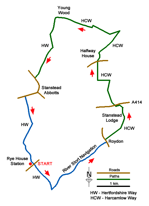
Starting and ending at Rye House railway station on the London Liverpool Street to Hertford East line, this circular route mostly follows canal towpaths and across fields and farmland. Parts of the Hertfordshire Way, Harcamlow Way and Stort Valley Way are included.
Before setting off, a short detour may be made to visit the remains of the Rye Gatehouse on the other side of the canal. As to the walk itself, from Rye House station, follow the canal to the right of the bridge and, after about half a mile, the first of the canal locks on the walk comes into view, Feilde's Weir Lock. The route switches direction immediately after the lock by crossing a footbridge to the left, then another footbridge over a weir. Keep bearing left to follow another branch of the canal, the Stort Navigation route that leads past two more locks, Lower Lock and Brick Lock en route to Roydon Marina Village. When the tow path reaches a road, turn right with the canal on your left and after another few minutes walking along the road, Roydon railway station comes into view beyond the canal. Cross the road bridge to the left over the canal at the level crossing.
After passing the station at the level crossing, follow the road ahead. A signed public bridleway soon appears on the right. Leave the road at this point to follow the edge of a grassy field on the right until a waymarker post indicates a right turn along a signed public footpath which skirts the private land of Stanstead Lodge on the left, leading to a tarmac lane. Turn left along the lane and then take the next signed public footpath on the right. Follow this track over a short rise to reach a field and then follow it as it contours round to the left to border some woodland on the right. Next follow the route as it switches to the right via an underpass below the A414. Continue ahead, bordering a field with hedgerow on the left. Ignore the first left turning after about a quarter of a mile but when you have covered approximately the same distance again, with Olives Farm in view ahead, take the signed public footpath to the left across a field and then turn sharp right past a copse to cross another field. The route to the north across a field crosses Hunsdon Road and Halfway House lies ahead.
Take the path to the right that bypasses the house ahead by skirting woodland. Follow an unsurfaced road but leave it at a hedge bordering a field on the right and follow the edge of the field with the hedge on your right initially north east before the route contours round to the left to cross more fields, continuing to follow part of the Harcamlow Way until it connects with the Hertfordshire Way and, although not signposted, the route links up with the Hertfordshire Way, at which point, signposts do appear. After turning left along the Hertfordshire Way, follow the track ahead across a landscape of vast open fields before it descends through woodland and the houses of Stanstead Abbots come into view. Turn left along the road and then right along the high street to locate the canal just before the Jolly Fisherman pub. The canal towpath leads back to Rye House station.
Messaging & Social Media
Message Walking Britain and follow the latest news.

Mountain Weather
Stay safe on the mountains with detailed weather forecasts - for iOS devices or for Android devices.