Walk 1742 - printer friendly version
Grit Fell from the Jubilee Tower near Quernmore Walk
Author - Andy Chaplin
Length - 7.7 miles / 12.5 km
Ascent - 1220 feet / 370 metres
Grade - moderate
Start - OS grid reference SD542573
Lat 54.009674 + Long -2.7003449
Postcode LA2 0QR (approx. location only)
This walk was devised as an accessible "sampler" for walking in the Forest of Bowland whilst travelling en route from South Yorkshire to the North Lakes. As such it needed to be in the AONB area, be easy to get to and be relatively easy and quick walking. The Jubilee Tower is close to junction 33 on the M6 and for anyone who wants a short walk while travelling up the west coast this walk gives you a chance to get out and walk for 4 hours.
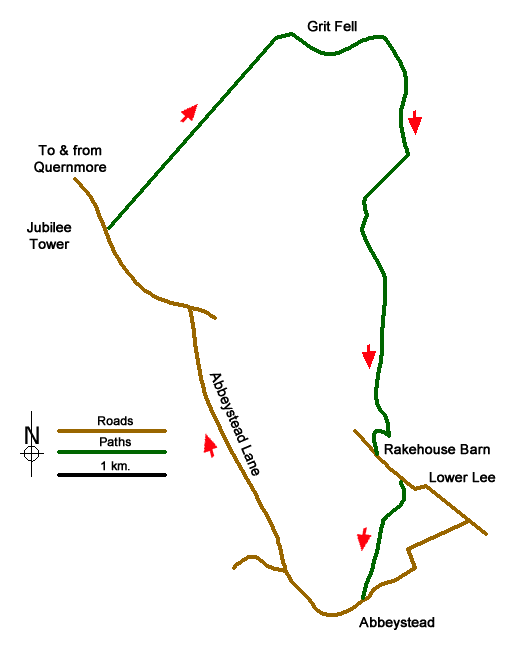
Park at the Jubilee Tower at grid ref. SD542573. Given that the first part of the walk can be very boggy, and the best views are behind you it may be worth doing the walk the other way around as your feet will stay drier for longer and the views will require less turning around. However, my route was to take the path at the side of the fence from the car park uphill towards the boundary stones that are visible on Grit Fell. There are great views westwards over Morecambe Bay as you climb up the fell.
Where the fence peters out there is a stile on your left. Here you take the path off to the right that heads over Grit Fell and then down to the moors track at grid ref. SD565588. Turn downhill and follow the stone track all the way down to Higher Lee and Rakehouse Barn. There are now good views of the Wyre valley.
Go left on the road to Grizedale Bridge and just before the river follow the path that goes in roughly the same direction as the river Grizedale to Abbeystead. This is a very pleasant village with a school that advertises that it only has 6 pupils in each year group.
From here the route is along is along the roads back to the car park. The first 500m is along the potentially, busiest part but there is little traffic on Abbeystead Road and from grid ref. SD554554 it is all unfenced. On the way you pass a sign to the Quaker Burial Ground near Meeting House Farm which is a reminder that the Quakers were well established in this part of Lancashire. Back at the car park it is possible to climb up the Jubilee Tower to take a last look at the area.
Messaging & Social Media
Message Walking Britain and follow the latest news.

Mountain Weather
Stay safe on the mountains with detailed weather forecasts - for iOS devices or for Android devices.