Walk 1752 - printer friendly version
Churnet Valley Walk
Author - Lou Johnson
Length - 2.6 miles / 4.2 km
Ascent - 520 feet / 158 metres
Grade - easy
Start - OS grid reference SJ994484
Lat 53.0328810 + Long -2.0103972
Postcode ST9 0BE (approx. location only)
This short Staffordshire walk in the Churnet Valley is an ideal introduction to this small but scenic area. In the early part of the twentieth century the area was marketed as "Little Switzerland" with the railways bringing many thousands of visitors from the surrounding towns and cities to enjoy the landscape. Today the valley retains its scenic charm and the Churnet Valley Railway operates steam hauled heritage trains.
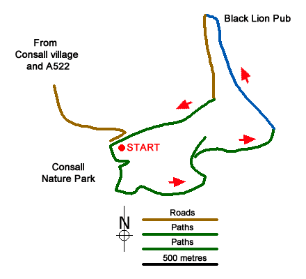
The start of the walk is the RSPB Consall Woods Visitor Centre (grid ref. SJ994484) which can be reached from the A520 Leek to Stone road near Wetley Rocks. From the centre of Consall village, brown signs direct you to Consall Hall Gardens. The Visitor Centre with its adjacent car park are reached by the access drive on the right just past the entrance to Consall Hall Gardens. After parking exit the car park at the opposite end to the Visitor Centre and follow the White Walk path. This leads you around a wooded steep-sided valley on a well-constructed path. The path then crosses the side of the valley offering a good view across the surrounding countryside.
After about fifteen minutes following the trail, you reach a bench (grid ref. SJ999483). Shortly after bear right onto the Purple Walk. This soon descends a long flight of steps to reach the valley floor. Keep left at the foot of the steps and continue across the River Churnet and the Churnet Valley Railway to reach the Cauldon Canal.
Turn left along the canal following the tow path. You soon pass the delightfully preserved station at Consall. Continuing along the two path, you soon reach the Black Lion Pub where food and drink is normally available. Walk under the railway, cross the river and then turn left along a track to reach a road (grid ref. SJ999486). Turn left up the road re-joining the White Walk to return to the car park.
Messaging & Social Media
Message Walking Britain and follow the latest news.

Mountain Weather
Stay safe on the mountains with detailed weather forecasts - for iOS devices or for Android devices.