Walk 1758 - printer friendly version
Newton House Plantation & Stony Leas Walk
Author - Andy Chaplin
Length - 10.3 miles / 16.7 km
Ascent - 900 feet / 273 metres
Grade - moderate
Start - OS grid reference NZ851028
Lat 54.4135400 + Long -0.6902240
Postcode YO22 5LN (approx. location only)
This North York Moors 10-mile walk offers some strange contrasts in landscape. Wild moorland, agricultural farmland and woodland never seem to gradually fade into each other. At one point you are in one, the next you are walking in a completely different landscape. Highlights of the route are the views across the North York Moors to the North Sea, and the May Beck and Falling Foss waterfalls.
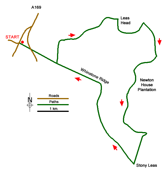
There is parking room for a couple of cars just off the A169 at NZ855026 but there is more room on Cow Wath Bank at NZ851028 along an old mining rake. From here walk the quarter mile along the rake to the main road, cross over and continue along the track towards the north west corner of the Newton House plantation.
Although a bridleway is shown on the map from a tumulus that you pass, the easier route to follow is the track under the pylons. This leads to a normally dry ford at Sheep House Rigg and continues eastwards above the plantation becoming the Lees Head Road track. Suddenly you leave the moors behind and are in the farmland valley heading towards Leas Head Farm.
Stay on the track all the way towards the farm then follow the footpath off to the right across the field. The path crosses Parsley Beck and goes through a small wood. As you come out keep to the left of the drainage ditch and when you get over the next hillock you will see a path ahead of you that you will join on the way to Foss Farm. Keep on this track past Foss Farm and on to Midge Hall and Falling Foss. It is only ? of the way through the walk but there is a chance to get a cup of tea here while admiring the waterfall.
A new wooden walkway on the eastern side of the May Beck marks the start of the Coast to Coast section down the May Beck. Carry on along this popular woodland walk to the car park then take the main track up the hill. The beck will now be below you and on your left. This track leads into the plantation and the route through is signed as the Moor to Sea cycle route. The track is quite open as it is a wide forestry track but sections of the forest, after it has been cut, looks devastated.
Keep on south to the trig point and gate at Stony Leas then take the moors track on the western side of the fence back towards the northwest. There are good views towards the coast, towards Fylingdales and eastwards towards Goathland. The path crosses the fence at Foster Howes then joins the Whinstone Ridge line at York Cross Rigg and heads back to the A169 and the parking places.
Messaging & Social Media
Message Walking Britain and follow the latest news.

Mountain Weather
Stay safe on the mountains with detailed weather forecasts - for iOS devices or for Android devices.