Walk 1764 - printer friendly version
The Cheviot from Langleeford Walk
Author - Lou Johnson
Length - 8.2 miles / 13.3 km
Ascent - 2000 feet / 606 metres
Grade - mod/hard
Start - OS grid reference NT953225
Lat 55.4962650 + Long -2.0759479
Postcode NE71 6RG (approx. location only)
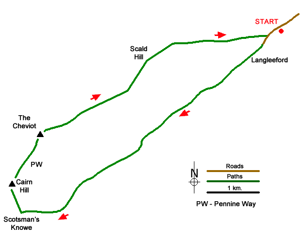
This walk to The Cheviot's summit starts in the Harthope Burn valley near Langleeford. The route follows the Harthope Burn climbing gently to reach Scotsman's Knowe. The route turns north to join the Pennine Way at Cairn Hill for the final ascent to the summit. The descent heads northeast to Scald Hill from where the route returns to the valley.
The start is the small roadside parking area (grid ref. NT953225) on the south side of the minor road from Wooler about 600 metres before Langleeford. After parking, follow the road to Langleeford and take the track through a gate. Continue along the clear track up the valley to reach some farm buildings at Langleeford Hope (grid ref. NT933208). The track soon ends so follow the footpath on the north side of Harthope Burn. The path fades in places but the way ahead is obvious with a steady climb up the valley. Reaching the head of the valley a short steeper section leads up to a fence at Scotsman's Knowe (grid ref. NT905190).
Turn right and keeping the fence on your left head uphill to a stile on Cairn Hill. Turn right onto the Pennine Way, which is paved for some of this section. Height is gained quickly, and you soon reach the summit of The Cheviot with its OS trig column perched on a high base. Despite being the highest point in the Northumberland National Park there is little to commend the view.
Continue ahead for 2.5 kilometres descending with the fence to your right to reach Scald Hill. This gradual descent does offer improving views which extend to the coast on fine days. From Scald Hill continue beside the fence for 500 metres. Just before the fence bends left, leave the fence (grid ref. NT933221), and descend on a good path into the valley. Reaching the road, turn left and the start is a short walk away.
Messaging & Social Media
Message Walking Britain and follow the latest news.

Mountain Weather
Stay safe on the mountains with detailed weather forecasts - for iOS devices or for Android devices.