Walk 1767 - printer friendly version
Allt Wen & Wales Coast Path from Trefechan Walk
Author - Lou Johnson
Length - 6.0 miles / 9.8 km
Ascent - 870 feet / 264 metres
Grade - easy/mod
Start - OS grid reference SN580806
Lat 52.4049300 + Long -4.0888150
Postcode SY23 1BU (approx. location only)
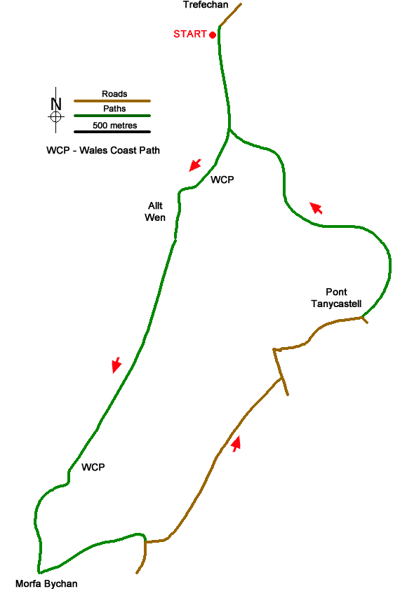
Starting from Tanybwlch Beach at Trefechan, near Aberystwyth, this walk follows a section of the Wales Coast Path. The route climbs onto Allt Wen and then stays about 130 metres above the sea for three kilometres before leaving the Wales Coast path to turn inland. The walk continues along tracks and paths to reach a lane which heads north along the River Ystwyth valley to reach Pont Tanycastell. The last section of the walk follows a path beside the River Ystwyth back to the start.
The start is the car park at the northern end of Tanybwlch Beach (grid ref. SN580806) which can be reached from the A487 in Aberystwyth. As you approach the car park you have a clear view of the conical shape of Allt Wen, which is the first objective of the walk. After parking walk past the barrier and continue along a track behind the beach with the River Ystwyth to your left. Reaching the end of the beach an arrow points to the cliff path. A series of zigzags lead up to a fence. The steep ascent follows the fence. If you need a rest, then the view back to Aberystwyth and along the coast improves as height is gained.
Stay on the undulating coast path with the view ahead improving as you make progress. The path gradually descends towards the Morfa Bychan caravan site soon reaching the access drive to the site. Turn left and continue ahead ignoring the coast path which goes off to the right. Cross a cattle grid and when the access drive turns sharp right, climb the steps and stile on the left into a pasture. Walk up the field and aim to the left of a telephone pole. Pass through a gap and then head right to a stile and a lane (grid ref. SN575774).
Turn left along the lane and continue to a junction (grid ref. SN584784). Bear left and continue downhill passing a church on your right and a cemetery on your left. Just before reaching the bridge over the River Ystwyth, go through a kissing gate on your left to join the riverside path. Continue along this path to reach the track at the back of the beach and return to the start.
Messaging & Social Media
Message Walking Britain and follow the latest news.

Mountain Weather
Stay safe on the mountains with detailed weather forecasts - for iOS devices or for Android devices.