Walk 1795 - printer friendly version
Beer & Branscombe Circular Walk
Author - Lou Johnson
Length - 5.5 miles / 8.9 km
Ascent - 1200 feet / 364 metres
Grade - easy/mod
Start - OS grid reference SY228888
Lat 50.6937040 + Long -3.0943556
Postcode EX12 3AJ (approx. location only)
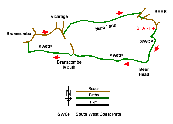
This energetic circular walk from Beer (Devon) follows the South West Coast Path around Beer Head and on through Branscombe Mouth before turning inland to the pretty village of Branscombe. The route continues along lanes to reach the village of Vicarage before climbing onto Stockham's Hill to join Mare Lane back to the start.
The walk starts from Beer Head car park (grid ref. SY228888) which lies on the south side of Beer. Leave the car park and turn right immediately joining the South West Coast Path. After a short descent, the path climbs to reach Beer Head from you get an excellent view along the coast – east to Seaton and beyond and west towards Branscombe. The route continues west descending from a gate and fingerpost down a narrow path with zigzags across the cliff and into the lightly wooded undercliff before reaching Branscombe Mouth.
From here the path swings to the right and climbs steadily above West Cliff. The climb onto the down is rewarded with an excellent view down into the village of Branscombe. The route continues through trees passing a footpath on the right. Stay on the SWCP to the next path junction (grid ref. SY196882) signed to Branscombe. Turn right here and descend to enter the churchyard of St. Mildred's church.
Exit the churchyard onto a lane and turn right. This lane sees little traffic but do take care. Continue past the thatched forge (National Trust) on your left and the Old Bakery tearoom. Just beyond the village hall, you can bear right down Mill Lane to visit the Manor Mill (National Trust) from here a path leads back up into the village. This route continues ahead at the junction with Mill Lane and follows the lane to reach Vicarage (grid ref. SY203889). Where the lane forks, keep right, and descend into the village. Pass the Masons Arms Inn on your left and turn right at the next junction signed to The Beach.
Climb the lane and after 300 metres turn sharp left onto a narrow lane which is closed to traffic (grid ref. SY205887). A short distance along this lane turn right onto a signed footpath to Beer and Stockham's Hill. The path climbs across the hillside. Ignoring paths on the left exit the trees at a stile. Follow the left-hand edge of the field and then forking right and the pass through a kissing gate in the hedge. Cross the next field to the left-hand edge of a stand of trees (grid ref. SY211890). Follow the track, which soon becomes Mare Lane, with the trees on your right and continue towards Beer. Pass Pecorama and the Beer Heights Light Railway and follow the main access road down to a road (Underleys). Turn right and then take the first footpath on the left (signed to the Village and Beach). This path leads you to Park Road. Turn left and then almost immediately right into Southdown Road which is signed to Beer Head car park. Continue ahead to return to the start.
Messaging & Social Media
Message Walking Britain and follow the latest news.

Mountain Weather
Stay safe on the mountains with detailed weather forecasts - for iOS devices or for Android devices.