Beer & Branscombe Circular
Jurassic Coast Walk
Region - Jurassic Coast
County/Area - Devon
Author - Lou Johnson
Length - 5.5 miles / 8.9 km Ascent - 1200 feet / 364 metres
Time - 4 hours 0 minutes Grade - easy/mod
Walk Route Description
Click image to see photo description.
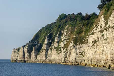
This energetic circular walk from Beer (Devon) follows the South West Coast Path around Beer Head and on through Branscombe Mouth before turning inland to the pretty village of Branscombe. The route continues along lanes to reach the village of Vicarage before climbing onto Stockham's Hill to join Mare Lane back to the start.
The walk starts from Beer Head car park (grid ref. SY228888) which lies on the south side of Beer. Leave the car park and turn right immediately joining the South West Coast Path. After a short descent, the path climbs to reach Beer Head from you get an excellent view along the coast - east to Seaton and beyond and west towards Branscombe. The route continues west descending from a gate and fingerpost down a narrow path with zigzags across the cliff and into the lightly wooded undercliff before reaching Branscombe Mouth.
From here the path swings to the right and climbs steadily above West Cliff. The climb onto the down is rewarded with an excellent view down into the village of Branscombe. The route continues through trees passing a footpath on the right. Stay on the SWCP to the next path junction (grid ref. SY196882) signed to Branscombe. Turn right here and descend to enter the churchyard of St. Mildred's church.
Exit the churchyard onto a lane and turn right. This lane sees little traffic but do take care. Continue past the thatched forge (National Trust) on your left and the Old Bakery tearoom. Just beyond the village hall, you can bear right down Mill Lane to visit the Manor Mill (National Trust) from here a path leads back up into the village. This route continues ahead at the junction with Mill Lane and follows the lane to reach Vicarage (grid ref. SY203889). Where the lane forks, keep right, and descend into the village. Pass the Masons Arms Inn on your left and turn right at the next junction signed to The Beach.
Climb the lane and after 300 metres turn sharp left onto a narrow lane which is closed to traffic (grid ref. SY205887). A short distance along this lane turn right onto a signed footpath to Beer and Stockham's Hill. The path climbs across the hillside. Ignoring paths on the left exit the trees at a stile. Follow the left-hand edge of the field and then forking right and the pass through a kissing gate in the hedge. Cross the next field to the left-hand edge of a stand of trees (grid ref. SY211890). Follow the track, which soon becomes Mare Lane, with the trees on your right and continue towards Beer. Pass Pecorama and the Beer Heights Light Railway and follow the main access road down to a road (Underleys). Turn right and then take the first footpath on the left (signed to the Village and Beach). This path leads you to Park Road. Turn left and then almost immediately right into Southdown Road which is signed to Beer Head car park. Continue ahead to return to the start.
Maps 

| Ordnance Survey Explorer 115 | Sheet Map | 1:25k | BUY |
| Anquet OS Explorer 115 | Digital Map | 1:25k | BUY |
| Ordnance Survey Explorer 116 | Sheet Map | 1:25k | BUY |
| Anquet OS Explorer 116 | Digital Map | 1:25k | BUY |
| Ordnance Survey Digital Map Subscription | |||
| Latest Ordnance Survey Discounts | |||
Other walks nearby
| Walk 2279 | Salcombe Regis & Weston Mouth | easy/mod | 5.1 miles |
| Walk 1550 | Charmouth & Lyme Regis Circular | easy/mod | 6.0 miles |
| Walk 2771 | Lyme Regis & Uplyme Circular | easy/mod | 5.5 miles |
| Walk 1551 | Seatown and Charmouth via Golden Cap | easy/mod | 5.0 miles |
| Walk 1636 | Danger Point & Ladram Bay from Otterton | easy/mod | 6.0 miles |
| Walk 2580 | Golden Cap & Charmouth | easy/mod | 5.0 miles |
| Walk 2030 | Budleigh Salterton, East Devon | easy/mod | 7.0 miles |
| Walk 1549 | Golden Cap from Seatown | easy/mod | 4.0 miles |
| Walk 2391 | West Bay & Burton Cliff | easy | 4.5 miles |
| Walk 3629 | Eggardon Hill from Loders | moderate | 8.4 miles |
Recommended Books & eBooks
South West Coast Path Map Booklet - St Ives to Plymouth
 Map of part of the southern section of the 630 mile (1014km) South West Coast Path National Trail. Covers the trail from St Ives to Plymouth along the west Cornwall and Devon coastline. This convenient and compact booklet of Ordnance Survey 1:25,000 maps shows the route, providing all of the mapping you need to walk the trail in either direction.
More information
South West Coast Path Map Booklet - Minehead to St Ives
 Map of the northern section of the 630 mile (1014km) South West Coast Path National Trail. Covers the trail from Minehead to St Ives along the north Devon and Cornish coastline. This convenient and compact booklet of Ordnance Survey 1:25,000 maps shows the route, providing all of the mapping you need to walk the trail in either direction.
More information
