Walk 1821 - printer friendly version
Circuit of Virginia Water Walk
Author - Peter Smyly
Length - 5.0 miles / 8.1 km
Ascent - 150 feet / 45 metres
Grade - easy
Start - OS grid reference SU980688
Lat 51.409765 + Long -0.59233511
Postcode GU25 4QF (approx. location only)
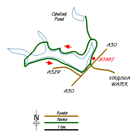
This walk involves an anti-clockwise circuit of the lake at Virginia Water in Surrey and additionally includes a "there and back" detour to Savill Gardens and Obelisk Pond. The route is mostly on the level on clear paths with a few gentle slopes up and down and, as long as the ground is dry, a pair of trainers should suffice rather than walking boots. This is the easiest way of exploring this area and starts from the car park to the east of the lake (grid ref. SU9806880). However a longer version starting from the railway station that also explores the Wentworth estate is Walk 1714.
From the car park you will see a sign by the lake shore that indicates the way to particular landmarks. It also states that a circuit of the lake is four and a half miles long. Turn right and follow the path by the lake (which will be on your left) until you reach Wick Pond with the giant Totem Pole beyond it.
Taking the path to the right of Wick Pond and passing the Totem Pole leads to Obelisk Pond, the reason for the name being obvious due to the tall obelisk on the hill overlooking the pond. Follow the path along the dam then the path turns left to a grassy area on a slight hill with tall trees and picnic tables. Savill Gardens is nearby where there is a shop, a cafe and public conveniences.
Returning to the Totem Pole, the circuit of the lake continues by taking the path to the right which runs more or less parallel to the north shore of the lake in an east-west direction. There are stretches where the lake cannot be seen at all due to trees and shrubbery on the left. Botany Bay viewpoint provides one of the exceptions. Valley Gardens is passed on the right and is worth a digression to explore it. The path continues to cross a bridge, with Johnson's Pond to the right. The path ahead appears to have temporarily "lost" the lake for a few hundred yards before it reappears at Five-Arch Bridge. Beyond the bridge, a few yards further on, a path appears on the left through the trees and by following it you shortly reach the point where you round a corner and start heading back along the south shore of the lake. Two separate features to look out for on the path to the south of the lake are the Lepta Magna Roman ruins and the cascades, before returning the car park.
Messaging & Social Media
Message Walking Britain and follow the latest news.

Mountain Weather
Stay safe on the mountains with detailed weather forecasts - for iOS devices or for Android devices.