Walk 1827 - printer friendly version
Ashford-in-the Water,Magpie Mine & Over Haddon Walk
Author - Lou Johnson
Length - 7.1 miles / 11.5 km
Ascent - 850 feet / 258 metres
Grade - easy/mod
Start - OS grid reference SK195697
Lat 53.223993 + Long -1.7093861
Postcode DE45 1QB (approx. location only)
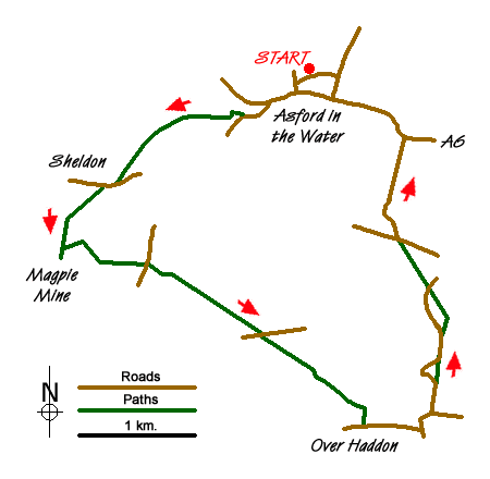
This Peak District walk explores the limestone country to the south of the River Wye. The start is the pretty village of Ashford-in-the-Water (grid ref. SK196697). There is a pay and display car park (grid ref. SK195697) in the centre of the village. After parking walk west along Church Street (with the church on your right) and turn left across the River Wye at the southern end of Fennel Street.
Reaching the A6, turn right for 200 metres and take minor road to Sheldon on your left. Reaching a sharp left bend, take the signed footpath to the right to a gate by the riverside. Here bear left and take path to Sheldon which slants uphill to a broken wall on skyline. Just before wall, turn left and continue uphill to near the crest of a spur overlooking Kirk Dale. Head through the dip in the hillside to a wood keeping continuation of wall on your right.
Walk up the side of the wood and over a stile. Continue parallel to the wood heading for a gap in next wall. The path continues to another wall. Continue straight onwards through a squeeze stile towards house in dip ahead and the village of Sheldon. Turn right and follow road towards village. After 70 metres go through the stile on your left. Go through the gate following the wall on your right. Pass a small stone barn and go over two stone stiles up through old strip fields. The wall on your right then ends and you bear slightly to the left to another stone stile. Climb this and again walk with a wall on your left, before bearing left at a signposted stone stile to head for the buildings of Magpie Mine.
After exploring the remains of Magpie Mine, return along the approach path just used but pass just right of the small, circular, roofless, stone building and into the right hand corner of this enclosure, to a stile. Cross this and turn right to follow the wall 200 metres to a squeeze stile. Once through the squeeze stile go left to a right angle of wall protruding into this field. Walk around the angle (waymarked) keeping this wall close on your left. Go through a small wooden gate and into Trueblue Lane. This walled green path leads down to the road in Kirk Dale (grid ref. SK180680).
Across the road, almost opposite, a stile can be seen beside a gate. Go straight up the field and between a gap at the right end of the hill top plantation, to climb a stile beside a gate. Turn right here and continue in a few metres to another stile. Turn left here on to Magshaw Rake (field). The path crosses the field diagonally to the left (SE) to a stile in the boundary fence.
Having climbed the stile turn left, the village of Stanton-in-the-Peak is beyond, and on the horizon, just right of the village, you can see Stanton Moor TV repeater mast. Keeping the fence on the left, follow the edge of the field round to a stile in the corner by a hawthorn tree (the path is waymarked at this point). Now turn right and head towards the stile in the wall ahead and continue diagonally across the next fields (passing left of the building) in the same direction to the Bakewell to Monyash road, at a stile by an ash tree, right of the gate in the corner (grid ref. SK191673).
About 10 metres along the road to the right look for a footpath sign and stile before the entrance to Melbourne Farm. Cross the stile and go diagonally across the field (SE) to the right end of the shelter plantation and continue in the same direction to the far corner of the next field. Over the stile, follow the wall to your left, and look for a stile in it nearly two thirds of the way down the field. Cross the stile and revert to the original direction, towards Stanton Moor mast, heading towards a trough in the wall. The stile is to the left of the gateway. Continue beside the wall on your right toward the farm ahead and on to the road at the edge of Over Haddon (grid ref. SK200665).
Turn left through the village of Over Haddon to a T-junction. Turn left on the Bakewell Road. Continue following this road (ignoring a turn to Youlgreave) going slightly uphill to the highest point of the road. The road bends left but continue straight ahead through the squeeze stile down into a valley, then up the other side to rejoin the road by a stile to the right of the gate. Turning right follow the road for about 250 metres around the right hand bend and just before the left hand bend there is a stone squeeze stile on the right. Go through this and go half left, down steeply, crossing a broken wall, to a wall running across the foot of the slope. Follow this wall to your left and continue straight ahead at gateway. Continue ahead with the hedge on right thro couple of fields to Bakewell-Monyash Road (grid ref. SK206678).
Turn right and after 20 metres take a footpath over a stone stile on the opposite side of the road. Follow footpath past some small buildings and over 3 stiles to another small stone barn. Go to the right around this barn and follow stiles towards large ash tree at the side of the Sheldon Road. Turn left here then after 30 metres take road signposted to Ashford. Continue to A6 and cross it taking path into Ashford-in-the -Water.
Messaging & Social Media
Message Walking Britain and follow the latest news.

Mountain Weather
Stay safe on the mountains with detailed weather forecasts - for iOS devices or for Android devices.