Walk 1835 - printer friendly version
Treyford & Didling from Hooksway Walk
Author - Lou Johnson
Length - 6.0 miles / 9.8 km
Ascent - 800 feet / 242 metres
Grade - easy/mod
Start - OS grid reference SU815162
Lat 50.9394940 + Long -0.8414262
Postcode PO18 9JZ (approx. location only)
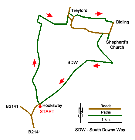
This West Sussex walk enjoys contrasting scenery within the South Downs National Park from woodland to rolling downs with expansive views. The route starts from Hooksway (grid ref. SU815162) a short distance from the B2141 between Chichester and Petersfield. Parking is limited and only available at the Royal Oak on the basis that you make use of the refreshment facilities provided.
After parking take the track heading north along the eastern boundary of Germanleith Copse for about a kilometre to reach a wider track coming in from your left (grid ref. SU815172). Continue ahead and when the track splits take the right hand fork and continue through Buriton Farm. At the next junction (less than 200 metres past the farm) turn left and continue along the track for a further 300 metres to where the track bends to the left (grid ref. SU818180). Leave the track and turn right following a bridleway into woodland. The route descends through the wood to reach open fields and a T-junction (grid ref. SU819186). Turn right and walk for 400 metres to another T-junction. Turn left and walk through Manor Far, to reach a tarmac lane. Turn left along the lane and when the lane bends to the right, turn left along a narrow tarmac access road.
At the end of this access road (grid ref. SU825187) take the signed footpath on your right that leads across a number of fields to the road at Didling (grid ref. SU837185). Turn right along the road and keep ahead at the first road junction. Stay on the lane to a right hand bend. If you wish to visit the "Shepherd's Church" take the track straight ahead, if not continue to follow the lane and take the signed bridleway/track on your left (grid ref. SU834182). This climbs gradually up through woodland to reach a junction with the South Downs Way on Didling Hill (grid ref. SU837174), Turn right along the South Downs Way and enjoy the wonderful views north.
The South Downs Way soon enters woodland as its skirts the eastern flank of Treyford Hill. A brief section of open downs is followed by more woodland. Reaching a clear junction of tracks (grid ref. SU824169) the South Downs Way turns sharp right. Your onward route continues straight ahead and all that remains is pleasant kilometre of walking back to the start.
Messaging & Social Media
Message Walking Britain and follow the latest news.

Mountain Weather
Stay safe on the mountains with detailed weather forecasts - for iOS devices or for Android devices.