Walk 1848 - printer friendly version
Turkdean & Notgrove from Cold Aston Walk
Author - Lou Johnson
Length - 6.5 miles / 10.6 km
Ascent - 700 feet / 212 metres
Grade - easy/mod
Start - OS grid reference SP129197
Lat 51.8757220 + Long -1.8140215
Postcode GL54 3BN (approx. location only)
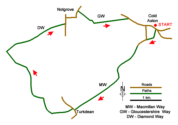
This Gloucestershire walk features typical rolling Cotswolds rolling countryside and visits three lovely villages - Cold Aston, Turkdean and Notgrove - the buildings of which are mainly constructed from local honey coloured stone. The route mainly follows well-trodden paths and tracks and provides a pleasant half day walk.
The start is the village of Cold Aston where limited parking is available near the Plough Inn in the centre of the village (grid ref. SP129197). After parking, face the pub and take the lane on its immediate left. After a short distance cross the stile, join a grassy track and follow the enclosed path between fences to a gate. You are now on the Macmillan Way, which is followed as far as Turkdean. Turn right to a stile and walk ahead with the field boundary on your right to reach Bangup Lane (grid ref. SP126194). Turn left and continue along the lane for 300 metres or so until the tarmac ends.
Continue along the gravel path into Turkdean. Pass Aston Road Wood on your left and continue to the road in Turkdean (grid ref. SP107176). Turn right along the road and after 100 metres take the waymarked bridleway on the left - the Sabrina Way. Follow the bridleway down into the valley ignoring the path coming in from the left at grid ref. SP101175. Reaching a gate (grid ref. SP100177) follow the path running north signed "footpath only".
Continue on this path with the stream to your left. At the next gate (grid ref. SP096183) fork left and head uphill only a grassy track. A wall comes in on your right and this followed to reach Downs Barn (grid ref. SP095187). At the corner of Rixon's Covert wood, turn left. Initially the path shadows a wall on your left before cutting across the field to the far corner of the field where the path meets the Diamond Way. Bear right here and walk towards the small wood. Bear right along the boundary of the wood and continue downhill into a shallow valley. Go uphill for just over 60 metres, go through the gate on your right and then continue to ascend through two more gates to reach Kitehill Barn (grid ref. SP101197). Join the tarmac track and continue ahead to a lane (grid ref. SP105198).
Turn left and take the first lane on the right into Notgrove village. At the next junction turn left (the drive to the Manor House is on the eight). Continue along this lane to reach the village green. Take the next lane on the right at the grassy triangular island. Continue down this lane for about 200 metres. Where the lane bends right, take the signed path through the gate on your left. Once in the field bear half left to reach a gate by the corner of a wood. Turn right along a track and then go left along the Gloucestershire Way through a splendid avenue of trees. This leads you to a lane (grid ref. SP121200). Turn right and return to the centre of Cold Aston.
Messaging & Social Media
Message Walking Britain and follow the latest news.

Mountain Weather
Stay safe on the mountains with detailed weather forecasts - for iOS devices or for Android devices.