Walk 1851 - printer friendly version
Cregennen Lakes & Pared y Cefn-hir Walk
Author - Lou Johnson
Length - 2.5 miles / 4.1 km
Ascent - 560 feet / 170 metres
Grade - easy/mod
Start - OS grid reference SH658143
Lat 52.7096760 + Long -3.9878768
Postcode LL39 1LJ (approx. location only)
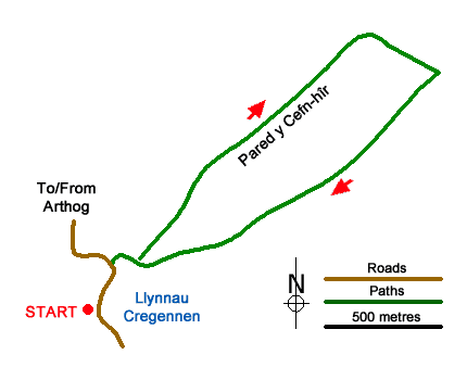
This short walk from the Cregennen Lakes below Cadair Idris offers exceptional views of many mountains in Snowdonia (Eryri). The route starts by the western lake and climbs up a ridge to the summit of Pared y Cefn-hir. There is a short section of easy scrambling which is more than compensated by the view from the summit. The walk continues down an undulating ridge before descending into a valley to return to the start.
The start is the free National Trust car park (grid ref. SH658143) which can be reached via a lane (signed to Llynnau Cregennen) from the A493 near Arthog which runs along the south side of the Mawddach Estuary. After parking turn left along the road with the lake on your right. Continue along the road which starts to rise and take the signed footpath on the right. Follow the grassy path to a wall and stile. Cross the stile and where the path forks bear left and follow the grassy path uphill.
The path rises steeply. Thankfully, it is only a short ascent. About half-way up there is a short scramble which can be avoided by a faint path to the right. The path continues to climb and soon reaches the summit of Pared y Cefn-hir. From the summit you get a bird's eye view across the Cregennen Lakes to the great cliffs of Cadair Idris. North the view includes the Mawddach Estuary with the Rhinog mountains rising beyond.
To continue follow a clear undulating path along the wide ridge to reach the remains of an old hill fort. Leaving the fort, the path continues along the ridge losing some height before climbing for a short distance. The path then descends to a stream (grid ref. SH668154) with the rocky outcrop of Pen Moelyn ahead. Turn right at the stream and follow a narrow path through heather downhill. Continue down to a wall and turn right onto a clearer path keeping the wall on your left. This path leads beside the lake to reach the stile used at the beginning of the walk. Reaching the road, turn left and retrace your steps back to the car park.
Messaging & Social Media
Message Walking Britain and follow the latest news.

Mountain Weather
Stay safe on the mountains with detailed weather forecasts - for iOS devices or for Android devices.