Walk 1853 - printer friendly version
Bredon Hill from Kemerton Walk
Author - Lou Johnson
Length - 5.2 miles / 8.5 km
Ascent - 800 feet / 242 metres
Grade - easy/mod
Start - OS grid reference SO949373
Lat 52.0340820 + Long -2.0757553
Postcode GL20 7JF (approx. location only)
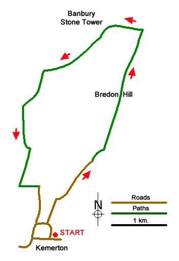
Starting from Kemerton this Worcestershire walk offers glorious views across the surrounding countryside including the Vale of Evesham, the Cotswold Hills, the Severn Valley, and the distant Malvern Hills. The route follows good paths and tracks climbing steadily across the eastern flank of Bredon Hill to reach the Banbury Stone Tower atop the northern escarpment. A alternative walk from Elmley Castle uses the northern approach to Eldon Hill .
The walk starts from the road on the east side of St Benet's Church (grid ref. SO949373). After parking walk north along the lane. Continue ahead at the first junction with Wing Lane. At the second junction continue ahead. Follow the lane for just under a kilometre into the countryside until you reach the end of the tarmac at a gate (grid ref. SO955384). Pass to the left of the gate onto a track. After 150 metres fork right through trees to a gate. Continue ahead with trees on your right along a clear track with view to the Malvern Hills and as far afield as the Brecon Beacons on your left.
Continue ahead ignoring a path to the right and shortly after another to the right. Go straight across a track (grid ref. 961399) and keep to the right-hand edge of two fields to reach a drystone wall on the northern escarpment of Bredon Hill with another fine view. Turn left along the wall passing the remains of Neolithic Kemerton camp on your left. You soon reach the north-west corner of Bredon Hill where the path swings left to reach the Banbury Stone Tower (grid ref. SO957402). It is worth planning to spend some time here so you can take in the expansive view. Sadly, the Tower is now adorned with modern telecommunications.
To continue head south along a grassy path with a wall on your right. The route soon passes through woodland (The Warren). After passing through a gate, turn sharp left keeping the trees on your immediate left. Continue to a gate (grid ref. SO945392). Pass through the gate and follow the clear track south After 600 metres the track bends left and then right before continuing south with views to Bredon and Kemerton villages. The track becomes a lane. Where the lane bends sharp right (grid ref. SO945381), turn left above a house. The onward path keeps to the left-hand field edge and after 300 metres turn right onto a clear track. Follow the track to reach the outskirts of Kemerton Village. Walk ahead and after 500 metres you reach the main road through the village. Turn left and return to the start.
Messaging & Social Media
Message Walking Britain and follow the latest news.

Mountain Weather
Stay safe on the mountains with detailed weather forecasts - for iOS devices or for Android devices.