Lilstock & East Quantox Head Walk
Walk 1856 - Route Maps
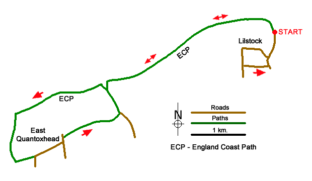
Route Map
Digital Maps - Copyright © 2011-2024. All rights reserved.
Sketch Map
Suggested Maps 

| Ordnance Survey Explorer 140 | Sheet Map | 1:25k | BUY |
| Anquet OS Explorer 140 | Digital Map | 1:25k | BUY |
It is recommended you take a map. The preferred scale is 1:25k.
Start Point Details
Ordnance Survey Grid Ref ST172452
Latitude 51.199992 Longitude -3.186465
Postcode TA5 1SU
what3words start cries.large.punctured
Walk description may contain detailed information on the start point for this walk.
Further Information
Somerset
Somerset is a rural county in south-west England. The high land of the Blackdown Hills, Mendip Hills, Quantock Hills and Exmoor National Park, contrast with the wide expanses of flat wetland including the Somerset Levels. Adding interest to the landscape are the extensive network of caves and the Cheddar Gorge. Exmoor National Park crosses the border into neighbouring Devon and provides excellent walking. The highest point in Somerset is Dunkery Beacon on Exmoor, with an altitude of 519 metres (1,703 feet). The coast also offers great walking especially the section of South West Coast Path west of Minehead.
Walk grading - Learn how each walk is assessed and select a walk to suit your ability and experience by going to Walk Grading Details.
Messaging & Social Media
Message Walking Britain and follow the latest news.

Mountain Weather
Stay safe on the mountains with detailed weather forecasts - for iOS devices or for Android devices.