Lilstock & East Quantox Head
Somerset Walk
County/Area - Somerset
Author - Lou Johnson
Length - 8.4 miles / 13.7 km Ascent - 650 feet / 197 metres
Time - 4 hours 50 minutes Grade - easy/mod
Walk Route Description
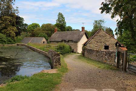
Click image to see photo description.
Starting from the Somerset village of Lilstock this walk follows the England Coast Path west to East Quantox Head along a rugged section of coast. The route includes three interesting churches, a bracing coastal section, and a taste of the Somerset countryside.
The start is the car park on the north side of Lilstock village close to the sea (grid ref. ST172452). After parking continue north to reach Lilstock Beach. Turn left along the England Coast Path which is followed for three kilometres to reach Kilve Beach car park. From here continue west along the coast path for a further 1.5 kilometres to a kissing gate (grid ref. ST130439). Turn left here and head inland. The path crosses three fields with the hedge on your left to reach a track (grid ref. ST130432).
Turn left along the track between hedges to a lane. Continue straight ahead along the lane into East Quantox Head. Reaching a T-junction, turn left pass a row of cottages and bear right onto a track with a fingerpost by the wall on your right. The path soon enters trees before emerging into a field. Keeping East Wood on your immediate right head east to pass to the left of St. Mary's Church (Kilve).
Bear left and pass the remains of The Chantry on your left which leads to Kilve Beach car park. At the coast, turn right and retrace your steps back along the England Coast Path to the car park at Lilstock. To continue pass through the car park and continue to a tarmac lane (grid ref. ST170449). Keep straight ahead. After 150 metres turn right along a narrow lane. At the next junction turn right uphill. A grassy track on the right provides access to the remains of St. Andrew's Church. Return to the lane and turn right. Follow the lane as it bends right and passes through the village. Continue past Lilstock Farm and at the next junction turn left back to the car park used at the start of the walk.
Maps 

| Ordnance Survey Explorer 140 | Sheet Map | 1:25k | BUY |
| Anquet OS Explorer 140 | Digital Map | 1:25k | BUY |
| Ordnance Survey Digital Map Subscription | |||
| Latest Ordnance Survey Discounts | |||
Other walks nearby
| Walk 2940 | Beacon Hill & Bicknoller Post from Kilve Beach | easy/mod | 7.0 miles |
| Walk 1822 | Hodder's Combe, Bicknoller Post & Higher Hare Knap | easy/mod | 5.8 miles |
| Walk 3412 | Dowsborough Fort from Holford | easy/mod | 6.0 miles |
| Walk 1696 | Weacombe Combe, Bicknoller Post, Kilve & Longstone Hill | easy/mod | 7.5 miles |
| Walk 2330 | Quantock Hills from Dead Woman's Ditch | moderate | 9.2 miles |
| Walk 1925 | Plainfield to Wills Neck | easy | 5.0 miles |
| Walk 1924 | Lydeard Hill to Wills Neck | easy | 2.6 miles |
| Walk 3211 | Crowcombe & Wills Neck | moderate | 7.3 miles |
| Walk 1973 | River Parrett from Pawlett | easy/mod | 7.1 miles |
| Walk 2211 | Minehead to Dunster | easy | 5.0 miles |
