Walk 1859 - printer friendly version
Chee Dale & Monk's Dale from Miller's Dale Walk
Author - Lou Johnson
Length - 7.3 miles / 11.9 km
Ascent - 1100 feet / 333 metres
Grade - moderate
Start - OS grid reference SK138733
Lat 53.2565300 + Long -1.7946055
Postcode SK17 8SN (approx. location only)
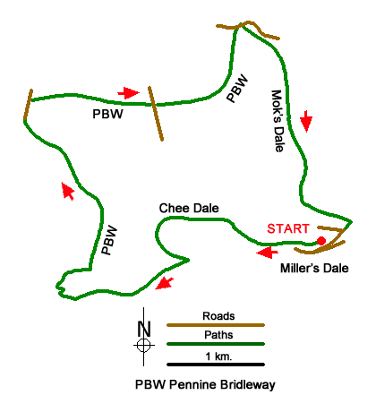
Starting from Miller's Dale this Peak District walk includes Chee Dale and Monk's Dale providing an interesting walk in limestone scenery. The route includes two sections of steeping stones beside the River Wye in Chee Dale before following a section of the Pennine Bridleway above Flag Dale. Turning east the walk crosses an area of upland pastures divided with stone walls. The route continues down Monk's Dale back to the start.
The walk starts from the car park at Miller's Dale (grid ref. SK138733) which is signed from the B6049. After parking turn right (with the station buildings behind you) along the Monsal Trail away from the impressive viaducts. After 160 metres you reach a finger post. Turn left for Miller’s Dale and continue down to the bottom. Turn right and follow the signed path to Chee Dale. Follow the riverside path under the railway to reach a footpath junction and footbridge (grid ref. SK128735). Continue ahead along a rocky path into the Chee Dale gorge.
A section of boardwalk is followed by the first set of stepping-stones. Continue to cross a footbridge and continue under the railway. Cross two footbridges and then negotiate a second set of stepping-stones. Then path passes under the former railway again before reaching a path junction (grid ref. SK115727) where you turn right onto the Pennine Bridleway. The path zigzags out of the valley before heading right to Mosley Farm. Follow the directions through the farm passing a stone barn on your left to a track. Follow the track, which soon bends left. Continue along the clear track with Tunstead Quarry on your left. The track leads north reaching a pair of houses on your right after just under two kilometres.
A short distance beyond the houses, turn right along an enclosed track still following the Pennine Bridleway. Pass through a gate and then continue through the next field with the wall on your right. Continue ahead along a track to reach Old Hall Farm (grid ref. SK121745). Pass through the farmyard to a road. Turn right and just before a telephone box, turn left, and continue along the Pennine Bridleway. Follow the walled track for 1.4 kilometres to a road (grid ref. SK130753). Turn right with the head of Peter Dale on your left and Monk's Dale on your right.
At the next fingerpost on the right, cross the stile and follow the grassy path into Monk's Dale. Follow the narrow path into woodland. You soon have an option of two paths. You can either take the lower or higher paths which meet before leaving the trees into the open dale. At the next path junction take the higher path over a crag from where there is an excellent view of the dale. Descend into the dale along with the stream on your right to cross a footbridge on the right. The path then climbs up to a wall which is followed left to reach a corner. Go right to reach a road where you turn left back to the car park.
Messaging & Social Media
Message Walking Britain and follow the latest news.

Mountain Weather
Stay safe on the mountains with detailed weather forecasts - for iOS devices or for Android devices.