Walk 1862 - printer friendly version
Earl Sterndale and High Wheeldon from Longnor Walk
Author - Lou Johnson
Length - 6.0 miles / 9.8 km
Ascent - 1400 feet / 424 metres
Grade - easy/mod
Start - OS grid reference SK088649
Lat 53.181129 + Long -1.8697809
Postcode SK17 0NU (approx. location only)
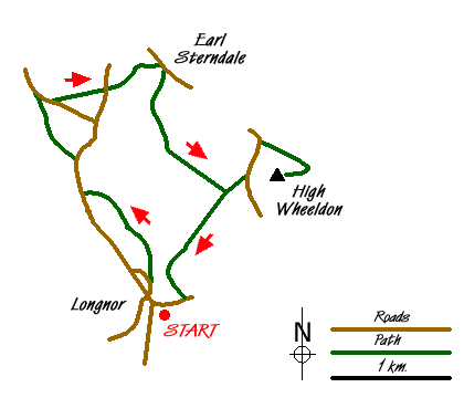
This Peak District walk starts from the attractive North Staffordshire village of Longnor. It then crosses the Dove Valley into Derbyshire, passes through Earl Sterndale to climb High Wheeldon before re-crossing the Dove back into Staffordshire. The scenery en-route is varied with excellent views throughout. Although not included in this walk you pass close to Chrome and Parkhouse Hills, which could also be climbed if energy permits.
The start is the centre of the village where a cobbled car park (Grid ref. SK088649) usually has room for a car or two. Otherwise alternative parking is available elsewhere in the village. From the Market Place walk north along Chapel Street and continue across Church Street into a tarmac lane. Turn right onto the signed footpath, which leads you behind a modern bungalow development and down a bank to join the access track (Grid ref. SK087655) to Underhill Farm. Turn left along this and at a junction of tracks bear right and continue towards Yewtree Grange. Pass this building to its left and follow the track up to the road. Turn right along the road and after 300 metres take the signed footpath on the left that follows a track to some houses. The way ahead leaves this track and becomes a path dropping down the hillside to a footbridge over the River Dove (Grid ref. SK078665). Cross this bridge into Derbyshire and continue on the path to the tarmac lane. To your left is Chrome Hill, while ahead rises Parkhouse Hill. Both of these hills are formed from old coral reefs and an ascent of either or both could be added to this walk is energy permits!
Assuming you are not climbing either of the hills, turn right along the lane and after a few metres bear half left across the grass crossing the flank of Parkhouse Hill to a gate. The path continues through this field and another to reach the road (Grid ref. SK084668) between Glutton Bridge and Glutton Grange. Cross the road and take the stile opposite and begin the climb up the hill to Earl Sterndale. Crossing a rather awkward wall stile continue through a gate to the right of a water trough and continue downhill to the village arriving at the front of the "Quiet Woman" pub. Facing the pub, take the path to its right through the back yard with its turkeys and other assorted 'wildlife'. This continues uphill across fields before descending into the Dove Valley to reach a track (Grid ref. SK089663). Turn left along this passing through Underhill Farm. Turn left on Green Lane and walk up to the road. Continue ahead along the road passing the old quarry on your left that is very popular with climbers. Just past the quarry take the signed footpath on the right. This leads in a large loop to the trig point on the summit of High Wheeldon.
The view from here is superb with the Upper Dove Valley particularly noteworthy. Chrome and Parkhouse Hills are very evident in the scene as is Axe Edge Moor at the head of the valley. Having enjoyed the panorama return the way you came tracing you steps to Green Lane. Rather than turn right to Underhill Farm continue straight ahead along the lane over Beggar's Bridge and back into Staffordshire. The path leads into a track and climbs to "Top o' tha' Edge" where you join a road. Turn right into the village and return to the start of the walk. At the end of a walk, Longnor offers a number of opportunities for refreshment including pubs with the converted Market Hall housing a cafe and craft shop recommended.
Messaging & Social Media
Message Walking Britain and follow the latest news.

Mountain Weather
Stay safe on the mountains with detailed weather forecasts - for iOS devices or for Android devices.