Walk 1866 - printer friendly version
East Prawle & Prawle Point Walk
Author - Lou Johnson
Length - 4.1 miles / 6.7 km
Ascent - 800 feet / 242 metres
Grade - easy/mod
Start - OS grid reference SX781364
Lat 50.2150200 + Long -3.7098959
Postcode TQ7 2BY (approx. location only)
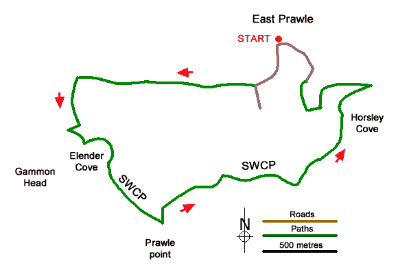
This circular walk starts from East Prawle and explores the countryside and coast to the south of the village. The route uses tracks and paths and a section of the South West Coast Path. The walk includes the section of coast between Gammon Point and Horseley Cove passing Prawle Point along the way with excellent views east to Start Point.
The start is the small parking are opposite the telephone box in the centre of East Prawle (grid ref. SX781364). After parking turn right (with the phone box behind you. Pass the small shelter on your left and continue along the lane with views of the sea ahead. Continue along the lane until its bends sharp left (grid ref. SX779361). At this point continue ahead onto a track (with fingerpost on the left).
Continue between hedges for 1.3 km ignoring all tracks off to the right and left. Reaching a T-junction of tracks with a gate opposite (grid ref. SX767361) turn left towards the sea. Continue downhill to reach the coast and the South West Coast Path above Elender Cove with Gammon Point on your right. Turn left along the coast path using the path nearest the sea. The path continues along the rocky coast before reaching Prawle Point. From here continue passing a row of former coastguard cottages on your left.
The onward path clings to the rocky foreshore around Langerstone Point to reach the sandy beach at Horseley Cove where the coast path swings left to reach a path junction with fingerpost (grid ref. SX786361). Bear left off the coast path and follow a track uphill. The track loops round to the left, turns right and reaches a junction of tracks (grid ref. SX783359). Turn right and continue up to a tarmac lane. Bear right and follow the lane back to the centre of the village and the starting point for this walk.
Messaging & Social Media
Message Walking Britain and follow the latest news.

Mountain Weather
Stay safe on the mountains with detailed weather forecasts - for iOS devices or for Android devices.