Walk 1869 - printer friendly version
Thorncombe Street from Bramley Walk
Author - Lou Johnson
Length - 6.0 miles / 9.8 km
Ascent - 800 feet / 242 metres
Grade - easy/mod
Start - OS grid reference TQ008449
Lat 51.1944400 + Long -0.5588337
Postcode GU5 0ES (approx. location only)
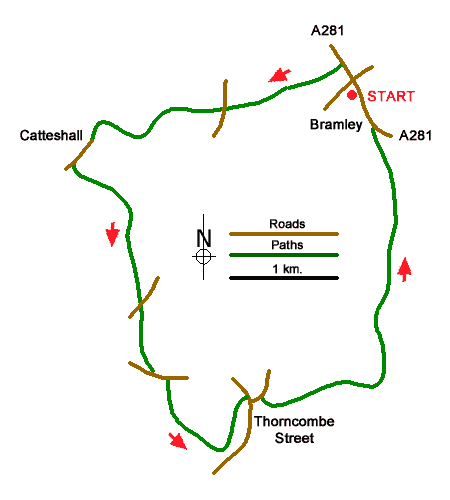
A circular walk from Bramley (Surrey) exploring the countryside to the southwest which lies on the northern flank of the North Downs. The route uses several green lanes and footpaths passing through Catteshall, Winkworth Arboretum and Thorncombe Street.
The walk starts from Bramley where limited on-street parking is available on Horsham Road close to the Jolly Farmer pub (grid ref. TQ008449). After parking walk north along the A281 and continue ahead at the mini roundabout along the left-hand pavement. Turn left at the first Bridleway fingerpost down a rough tarmac road (grid ref. TQ007451). Continue ahead, ignoring paths to the left and right, skirting the edge of a golf course on your right. At the end of the golf course the bridleway meets Foxburrow Hill Road at a post box (grid ref. SU997477).
Go straight across and continue along a signed public bridleway which loops around the north side of Fairly Hill. Ignore a path on the left into the trees and shortly enter trees to reach a junction (grid ref. SU990445). Turn right and continue to a track (grid ref. SU987446). Turn left and follow the track which soon joins a tarmac road (Catteshall Lane). Continue ahead at the first road junction and then turn left at the next junction (grid ref. SU984442). Pass a large black and white house on the left and the bear left following the tarmac drive. You soon reach the entrance to Catteshall Manor on the right. At this point continue straight ahead following the track for a kilometre to reach Munstead Heath Road (grid ref. SU990430).
Cross the road and continue along a narrow bridleway. Go straight ahead at the first junction and continue south to Alldens Lane (grid ref. SU991424). Turn left and after 100 metres take the path on the right with adjacent fingerpost. The path leads through trees which are park of Winkworth Arboretum. After just under a kilometre of pleasant woodland walking you reach a large house on the left. Just after the house turn left onto a footpath heading north. The path crosses several fields to exit onto a lane (Alldens Hill). Turn right and walk the short distance into Thorncombe Street. At the next junction turn left to Bramley (grid ref. SU999422).
After 70 metres turn right onto a bridleway (fingerpost hidden in bushes). Initially between hedges the path soon crosses open pastures before briefly passing through trees. Leaving the trees cross the next field to reach a junction (grid ref. TQ010423). Continue north past Upper Bonhurst on your right. Continue along an access drive. Where this bends right, continue ahead along an enclosed green lane. The track reaches a house on the left followed by a junction of tracks (grid ref. TQ011431). Keep straight ahead ignoring tracks off to the right and left. Follow the track north past Hurst Hill Farm continuing towards Bramley. The path exits onto The Coombes in a housing estate. Turn right and immediately left along Ricardo Court. Where this road bend left continue ahead along an enclosed footpath. Follow this path and exit onto the A281. Turn left along High Street back to the start.
Messaging & Social Media
Message Walking Britain and follow the latest news.

Mountain Weather
Stay safe on the mountains with detailed weather forecasts - for iOS devices or for Android devices.