Snailbeach & the Stiperstones Walk
Walk 1871 - Route Maps & Profile
Route Map
Digital Maps - Copyright © 2011-2024. All rights reserved.
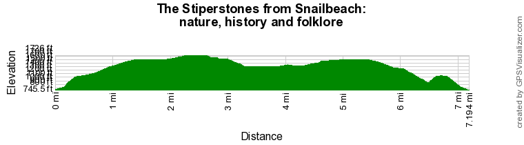
Route Profile
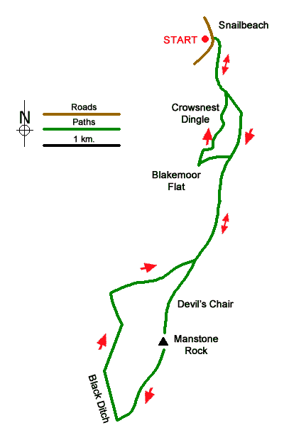
Sketch Map
Suggested Maps 

| Ordnance Survey Explorer 216 | Sheet Map | 1:25k | BUY |
| Anquet OS Explorer 216 | Digital Map | 1:25k | BUY |
| Ordnance Survey Explorer 217 | Sheet Map | 1:25k | BUY |
| Anquet OS Explorer 217 | Digital Map | 1:25k | BUY |
| Ordnance Survey Digital Map Subscription | |||
| Latest Ordnance Survey Discounts | |||
It is recommended you take a map. The preferred scale is 1:25k.
Start Point Details
Ordnance Survey Grid Ref SJ373022
Latitude 52.613937 Longitude -2.92746
Postcode SY5 0NZ
what3words start drags.vegetable.youngest
Walk description may contain detailed information on the start point for this walk.
Further Information
Shropshire Hills
This National Landscape (formerly AONB) consists of a number of areas of hills centered on Church Stretton. The hills are known for the variety, extensive network of paths and wonderful scenery. The most popular hills are the Long Mynd but others including Wenlock Edge, the Stiperstones and those around Clun are also gaining in popularity. Shropshire Hills Walking Guide
Shropshire
Shropshire is wonderful county for walking with the high ground concentrated in the south. The north is flat and an extension of the Cheshire Plain. In contrast, the southern half of the county contains some of the finest walking along the Welsh Borders with the Long Mynd and associated hills, Brown Clee Hill, Clun Forest and Wenlock Edge all offering many high-quality walks. To the west of the county, the Offa's Dyke National Trail runs north to south and offers the basis for many excellent circular walks.
Walk grading - Learn how each walk is assessed and select a walk to suit your ability and experience by going to Walk Grading Details.
Messaging & Social Media
Message Walking Britain and follow the latest news.

Mountain Weather
Stay safe on the mountains with detailed weather forecasts - for iOS devices or for Android devices.