Walk 1871 - printer friendly version
Snailbeach & the Stiperstones Walk
Author - Daryl Smith
Length - 7.0 miles / 11.4 km
Ascent - 1400 feet / 424 metres
Grade - moderate
Start - OS grid reference SJ373022
Lat 52.6139370 + Long -2.9274599
Postcode SY5 0NZ (approx. location only)
This is a superb walk in an area rich in history and folklore with outstanding scenery and wildlife coupled with lovely views. Our route includes the main part of the Stiperstones ridge with its fascinating rock formations. The Stiperstones extend to the south beyond our route should you wish to extend the walk. The walk starts from the village of Snailbeach south-west of Shrewsbury, turn off the A488 at Ploxgreen near Minsterley. Car parking is extremely limited in Snailbeach, and it is best to use the village hall car park, parking is free, but donations are requested. There are public toilets at the car park. Snailbeach Mine is well worth visiting; Guided tours including an underground experience can be booked with Shropshire Mines Trust. There are no refreshment facilities on the route, but the welcoming Stiperstones Inn is only 1.25 miles (2km) south along the lane from Snailbeach. If you would like to visit the inn on your way round, a similar route then please refer to walk 3529.
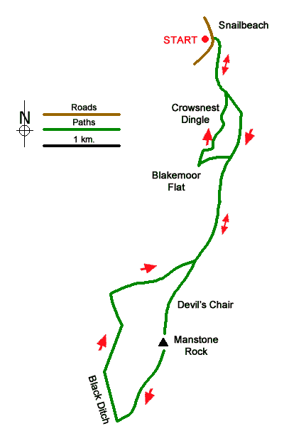
From the car park (grid ref. SJ373022) go up the lane in the direction of Lordshill, at the top of the first incline turn right into the mine site. Just behind the shaft with timber headgear you will see steps at the side of another mine entry, this is the start of our path. Go uphill through trees onto Resting Hill. Out of the trees go slightly right of straight ahead, on a flat area close to the hilltop veer left to a kissing gate. As you cross Resting Hill, long distance views to the north and west open up and once through the kissing gate you are rewarded with a view down the tree-lined valley of Crowsnest Dingle.
Follow the left-hand fence line at first then veer right and follow a clear path through heather and whinberry turning right onto a wider track. Ignore the wide green path at Blakemoor Flat and the jagged outline of the Stiperstones will soon be in sight followed by developing views to the west and south. Look down into Mytton Dingle and you will see Stiperstones village at the mouth of the valley.
The Stiperstones ridge is formed by a quartzite rock upended by unimaginable geological forces when continents collided, with a dramatic jagged profile created by shattering in the last ice age. This exposed sedimentary quartzite is unique in England. Named outcrops of rock in the order that you approach are Shepherd's Rock, Devil's Chair, Manstone Rock (the highest point) and Cranberry Rock.
Folklore abounds in this strange landscape. Some say that the Devil sits on his chair during the summer solstice to recruit followers whilst others maintain that the Devil has not been seen in these parts since he was outwitted by Slashrags the Tailor at Cranberry Rock! The winter solstice is also not free of the supernatural; the ghost of Wild Edric, a Saxon warlord who fought against the Norman Conquest, is said to gallop on horseback over these hills through the longest night pursued by that of his wife.
At Cranberry Rock go slightly right down the southerly end of the ridge; ahead you can see Nipstone Rock on the detached section of the Stiperstones. Just before a main entrance into the nature reserve turn sharp right and follow a path along the line of Black Ditch. At the next entrance to the nature reserve turn right on a bridlepath, continue to follow the bridlepath. You will soon arrive at a bridlepath crossroads, turn right, and go past a small reservoir back to the top of the hill close to Shepherd's Rock; retrace your steps back to Blakemoor Flat.
At Blakemoor Flat on the way out, you probably noticed an incongruous block of pasture fenced off and excluded from surrounding access land but intersected by a public footpath. Go through the pasture back onto open moorland following an indistinct track to a path at the head of a valley. Drop down through heather and whinberry at first, then gorse and into the lovely tree-lined valley rejoicing in the name of Crowsnest Dingle.
In front of a pretty cottage the path joins an access track, continue downhill. Immediately after leaving the property boundary re-enter the nature reserve on a path to your right. This path winds its way up the valley side back to the previously used kissing gate at the edge of Resting Hill pasture. Snailbeach Mine site is well worth exploring as you make your way back downhill. For an alternative route back, you can turn right at the last kissing gate, then right again following a path past Lordshill Farm onto a lane turning left through the mine surface back to the village hall.
Messaging & Social Media
Message Walking Britain and follow the latest news.

Mountain Weather
Stay safe on the mountains with detailed weather forecasts - for iOS devices or for Android devices.