Walk 1889 - printer friendly version
White Nothe from Ringstead Bay Walk
Author - Lou Johnson
Length - 5.8 miles / 9.4 km
Ascent - 800 feet / 242 metres
Grade - easy/mod
Start - OS grid reference SY751815
Lat 50.6326590 + Long -2.3534333
Postcode DT2 8NG (approx. location only)
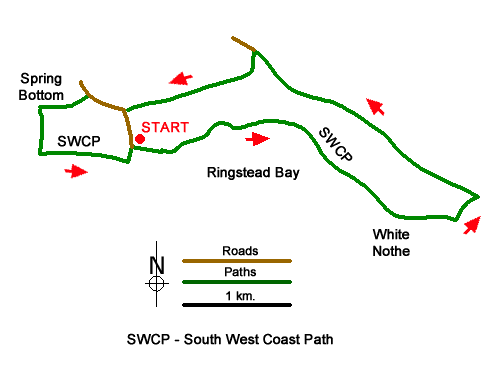
Starting from Ringstead Bay this Dorset walk along the Jurassic Coast follows the South West Coast Path onto White Nothe where the chalk cliffs rise over 500 feet above the sea. In places this section of coast has seen dramatic landslips especially near Burning Cliff. The return route follows inland paths and tracks across a pleasant rolling green landscape.
The start is the large pay and display car park at Ringstead Bay (grid ref. SY751815). After parking, walk towards the sea and take the first lane on the left (Fishers Place) following the South West Coast Path. Follow the lane as it bends right and then left to reach Shore Cottage where you continue along a cliff top path. A short climb follows to cross two footbridges after which the gradient steepens to pass the charming wooden chapel of St. Catherine's by the sea (grid ref. SY763817).
Passing Holworth House down on your right you are nearing the end of the initial climb onto White Nothe. Before passing White Nothe Cottages enjoy the retrospective view west along the coast. There is also a fine view east as far as Durdle Door. 600 metres beyond the cottage leave the South West Coast Path (grid ref. SY778809) and turn inland through a gate. Follow the path along the left-hand side of a field to reach Dagger's Gate. Turn left through the gate and follow the path with the field boundary on your right.
The undulating path continues for two kilometres passing Sea Barn Farm on your left to join the farm's access drive (grid ref. SY764820). Continue uphill for 400 metres to just before the NT car park and turn left through a gate (grid ref. SY761823). (If you reach a gate across the road and a stile, you have gone too far up the road.) The path descends steeply and after 100 metres go right to a stile (grid ref. SY761820). Continue left to another stile in a hedge and maintain direction soon crossing a track leading left to South Down Farm. Continue ahead to reach a road (grid ref. SY751818).
Turn right and walk uphill for 350 metres and turn left onto a path at a fingerpost (grid ref. SY748819) just opposite "Wildacre" on the right-hand side of the road. Turn right through a gate after 100 metres and follow the path through woodland along a shallow valley. Ignore the first path on the left and continue for a further 200 meres to the next path junction (grid ref. SY744818) and turn left down through trees to the South West Coast Path. Turn left and follow the coast path back to the start in Ringstead Bay.
Messaging & Social Media
Message Walking Britain and follow the latest news.

Mountain Weather
Stay safe on the mountains with detailed weather forecasts - for iOS devices or for Android devices.