Walk 1893 - printer friendly version
Ainthorpe Rigg & Little Fryup Dale Walk
Author - Lou Johnson
Length - 5.6 miles / 9.1 km
Ascent - 800 feet / 242 metres
Grade - easy/mod
Start - OS grid reference NZ717083
Lat 54.4650210 + Long -0.8953258
Postcode YO21 2NB (approx. location only)
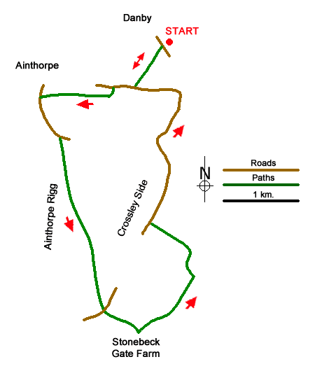
This varied walk from near the Danby Lodge North National Park Centre offers a taste of the North York Moors National Park. The route includes a path through pastures to reach Ainthorpe from where the walk climbs steadily onto Ainthorpe Rigg with its archaeological remains. A descent down Crossley Side leads to Little Fryup Dale, Danby Castle, Duck Bridge, and a return to the start.
The start is the large pay and display car park a short way south from the Danby Lodge National Park Centre (grid ref. NZ717083). After parking return to the entrance and turn right towards the Centre. After 30 metres, just by the entrance to the centre, turn left through a gate. Follow the clear path ahead, crossing the railway to reach Easton Lane. Turn right and walk for 300 metres past Kadelands House to take the first path on the left. Pass through a small gate and follow the left-hand side of the field to the field corner. Turn right and initially keep the left to reach a gap from where the path continues along the right-hand side of the field. At the end of the field join a walled track and follow this to exit onto Brook Lane in Ainthorpe (grid ref. NZ704078).
Turn left uphill. Pass the Fox and Hounds Inn and Tennis courts (on both sides of the road). Reaching the point where the lane bends left, turn right off the road onto a grassy bridleway (grid ref. NZ706073). The bridleway rises gently across the open moor. You soon pass a standing stone and just over a kilometre after leaving the lane you reach the steep escarpment of Crossley Side where you can the view across Little Fryup Dale.
The onward path drops steeply right across the escarpment to a lane junction (grid ref. NZ711055). Go straight ahead and follow the lane with a wall on your left. Cross a cattle grid. Continue along the lane to reach Stonebeck Gate Farm. Just after the farm turn left onto a signed bridleway passing in front of buildings and a house on your left. Follow the access drive to just before Forester's Lodge (grid ref. NZ720059). Turn right through a gate and veer left to another gate after which a short track leads you the next field. The onward route curves left following a wall (on your right) to a stream. Continue up between walls to Castle Lane.
Bear right along Castle Lane. After 800 metres you pass the remains of Danby Castle on your right. Shortly after passing the castle fork right and continue down the lane to Duck Bridge. At the bridge do not cross the River Esk but keep left along the lane. After 500 metres you reach a gate and fingerpost on your right. Turn right and follow the path used at the start of the walk back to the car park by Danby LoDge.
Messaging & Social Media
Message Walking Britain and follow the latest news.

Mountain Weather
Stay safe on the mountains with detailed weather forecasts - for iOS devices or for Android devices.