Walk 1917 - printer friendly version
Rackham Hill from Amberley Walk
Author - Peter Smyly
Length - 6.5 miles / 10.6 km
Ascent - 700 feet / 212 metres
Grade - easy/mod
Start - OS grid reference TQ026117
Lat 50.895677 + Long -0.54247868
Postcode BN18 9LR (approx. location only)
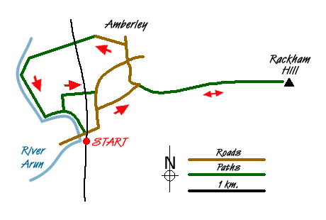
Amberley is a village in the Horsham district of West Sussex and it is at the foot of the South Downs. The village lies about a kilometre to the north of Amberley railway station and the South Downs Way passes between the two with walking possibilities along it to the west or east. This walk suggests a broadly circular route, though with a few variations and focuses on part of the South Downs ridge to the east of Amberley.
A variety of scenery is offered by this walk along part of the South Downs Way, and it includes a walk by the River Arun and a visit to the picturesque village of Amberley, location of Amberley Castle, which is passed on this route. There are a few relatively steep sections on the Downs but gradients are mostly easy. By following a map of the area, route finding should present no difficulties. Once you are on the South Downs Way, even in mist, it would be hard to lose your way. The walk along this section of the South Downs is popular not only with walkers but cyclists and some joggers too. A train trip to Amberley will enable the walk to be done by public transport with trains running normally at least hourly.
From the station, turn left down the station approach and, at the T junction ahead, cross the main road, the B2139, taking care with oncoming traffic, to the pavement on the other side. Now pass under the railway bridge (left) and take the signed public footpath almost immediately to the right. The path ahead crosses a stile before shortly turning left where the River Arun appears, also on the left. This bit of the route concludes the walk later when done in reverse. Next, before you reach the footbridge that crosses the river on the left, take the signed footpath to the right which leads across fields before turning right over a bridge over the railway line. At the T junction ahead, turn right along the pavement on the right side of the road, and then, when a sign indicates the South Downs Way soon after this, cross the B2139 and follow the path on the other side of the road which runs parallel to the road until it meets with High Titten, a road which gains height and passes between the quarry on either side of it through the trees. As the road up the hill levels off, a road appears on the left, but continue to follow the road ahead as it curves round to the right, and then take the narrow footpath up through the trees to the left which soon emerges into the open and this is the first relatively steep bit. You may see some poppies to either side of the path with chalk underfoot and a barbed wire fence either side of the route, a fence which will keep you company all the way to Rackham Hill. Downs Farm appears on the right.
The path levels out a bit before another steep pull up leads to the viewpoint of Amberley Mount. The best view is looking back the way you have just come up the hill, but the village of Amberley can be seen to the north-west with the houses of Cross Gate further along to the right of it. A distant view of the sea can be glimpsed to the south while the view west is of the South Downs route going the other way. The stretch between here and Rackham Hill is a mixture of fairly level path or gentle gradients. The highest point of Rackham Hill is, as the ordnance survey map indicates, marked by a triangulation pillar. This pillar, seen to the right of the South Downs Way path, is surrounded by grass and there is no public right of access due to the barbed wire fence that borders the path. Were it not for the triangulation pillar, the highest point would be unclear as the top is more or less level.
If time and weather conditions are favourable, it would be possible to walk further to the east along the South Downs Way. This particular walk turns back at this point and repeats the route in reverse as far as the point where the path rejoins the tarmac road and here you turn down Mill Road to the right, between trees which form a canopy overhead at one point. You then go down to a T junction with a busy main road (the B2139 again) which needs crossing with care, then follow the road straight ahead into the village of Amberley which has a village store and a tea room along with various houses that have thatched roofs. A left turn just past the tea room leads past more thatched roofs to Amberley Castle and the return route. A public footpath to the left offers a more direct approach back to the station via the main road. But a longer and pleasanter route is to go past the castle, even though it involves crossing the railway line. The path then continues across fields to reach the River Arun where you turn left and follow the course of the river. From here, you can see where you were earlier on in the walk up on the ridge, now some way off in the distance. The route and the river swing round to the left and bring you back to the point where early on in the walk you left the river to turn off down a footpath a cross a field. Now it is a simple matter of following the outgoing route back to the station.
Messaging & Social Media
Message Walking Britain and follow the latest news.

Mountain Weather
Stay safe on the mountains with detailed weather forecasts - for iOS devices or for Android devices.