Walk 1922 - printer friendly version
Goathland & Howl Moors Walk
Author - Andy Chaplin
Length - 11.2 miles / 18.2 km
Ascent - 700 feet / 212 metres
Grade - moderate
Start - OS grid reference SE855986
Lat 54.3757380 + Long -0.6852693
Postcode YO22 5NN (approx. location only)
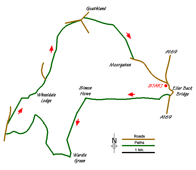
This North York Moors walk crosses Two Howes Rigg and circles the Goathland and Howl Moors. The Wheeldale Beck valley is very pretty and if you time the walk correctly you may even be able to line up with other spotters as a NYMR train comes past at Moorgates.
Park just up from the Eller Beck Bridge (grid ref. SE855986) and get the road section over first thing. It is probably best to wait until there is a good break in the traffic before going over the bridge - judging by the number of times the walls are rebuilt and given that there is no pavement. It is however, just a short, fast walk to get to the track at the other side that leads off down to Fen Bogs.
Go right at the track fork and cross over the NYMR track and up onto the moors path that leads all the way up to Simon Howe standing stones and cairn. Take the furthest path (of two quite close together) which leads south down Simon Howe Rigg.
At Wardle Green there is a bridge over the Blawath Beck before you go into the forestry area. Keep going south for a short while until you get to a crossroads at SE824962 then turn right and follow the forestry road to the next junction. Here, I chose the road to the right that goes via Gale Hill Point to Wheeldale Bridge. The advantage is that it is closer to the open country to the north; the disadvantage is you have to climb a gate at the end.
Go over the road "bridge" (which would be great fun in the ice and snow) then take the path up the Wheeldale Road path on the right. There is a pile of stones that indicates the path down Skivick Crag to the Wheeldale Beck stepping stones and there are some large boulders on the descent that would make a good stopping place.
Over the stepping stones take the path to the left towards Wheeldale Lodge and then Hunt House where there is a new sign indicating the bridleway on the right to Goathland. There are several paths skirting above the Hunt House Road and I chose one slightly below the rocks along the crest to your right. Similarly you can choose to cut through by The Tarn or continue around more northerly just above the road into Goathland.
In Goathland pass the church then take the path on your right towards the old "incline" railway track. Part of this path is unfortunately made into a "barbed wire corridor" for no obvious reason. At the old track turn right and follow it to Moorgates where you come to the road bridge for the NYMR track. With luck or good timing you may see something passing over the bridge.
From here it is a further 1km uphill back to the parking place.
Messaging & Social Media
Message Walking Britain and follow the latest news.

Mountain Weather
Stay safe on the mountains with detailed weather forecasts - for iOS devices or for Android devices.