Walk 1943 - printer friendly version
Cheddington to Tring via Marsworth Walk
Author - Peter Smyly
Length - 8.0 miles / 13 km
Ascent - 500 feet / 152 metres
Grade - easy/mod
Start - OS grid reference SP922185
Lat 51.857481 + Long -0.66262942
Postcode LU7 0SQ (approx. location only)
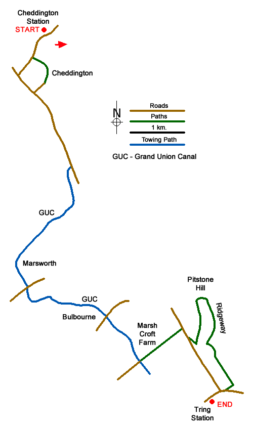
This is a route that can be completed by using two adjacent railway stations, Cheddington in Buckinghamshire and Tring in Hertfordshire. The route follows a scenic section of the Grand Union Canal and passes an old church with an avenue of yew trees. There are fine distant views of Southend and Westend Hills and the walk finishes with a climb up Pitstone Hill to join part of the Ridgeway, concluding at Tring station via Aldbury Nowers. Despite the well-known chalk hill of Ivinghoe Beacon being a distinctive landmark in the Chilterns, for long periods on this walk it is either not seen due to the lie of the land or else it appears diminutively on the distant horizon.
From Cheddington station, exit the station car park and follow the road to the right at the T junction. Take the first footpath on the left. The path leads ahead past the church and turns right to reach Cheddington village. Turn left along the main road and follow it as far as a bridge ahead with the canal appearing on the right, a location known as Cooks Wharf. This point marks one of the better viewpoints for seeing Southend Hill which appears a bit like a whaleback sloping down from left to right with a row of houses on the skyline. Follow the tow path of the canal to the right and the route passes the Marsworth series of canal locks en route towards and beyond the village of Marsworth itself where the route switches from right to left via a bridge. Marsworth village itself is slightly off route but is clearly seen on the other side of the canal.
When Marsworth top lock is reached, the path on the left comes to an end but the route continues on the right. Follow the tow path ahead along a secluded section of the canal as far as a bridge where the route switches sides again, this time from right to left. For this route, rather than simply following the canal to the end point, leave it by following the road beyond the bridge as it leads over the railway line and past Marsh Croft Farm and Park Hill Farm to reach a busy road at a T junction. Cross the road with care, turn right and take the next public bridleway on the left. When the bridleway reaches a junction, take the left turning which leads across fields past Northfield Grange before climbing steeply up to Pitstone Hill, the only steep ascent of the whole route.
For people who have previously walked to Ivinghoe Beacon along part of the Ridgeway from Tring station, this juncture will be familiar as the path up the hill joins the Ridgeway at the point where the path from the Tring direction emerges from woodland on to open hillside. This point is where the county boundary of Hertfordshire meets with Buckinghamshire. Ivinghoe Beacon, having remained largely out of sight for much of the walk, continues to remain hidden and can only be seen by making a short detour in the opposite direction to the conclusion of this walk which is through the woods of Aldbury Nowers. Follow the path ahead as it loses altitude and eventually a crossroads of paths is reached. Tring station is now about a quarter of a mile away by turning right to reach a road and following it all the way to the station.
Messaging & Social Media
Message Walking Britain and follow the latest news.

Mountain Weather
Stay safe on the mountains with detailed weather forecasts - for iOS devices or for Android devices.