Walk 1954 - printer friendly version
Fingest & Turville from Hambleden Walk
Author - Lou Johnson
Length - 11.4 miles / 18.5 km
Ascent - 1300 feet / 394 metres
Grade - moderate
Start - OS grid reference SU785855
Lat 51.5629250 + Long -0.8689345
Postcode RG9 6TL (approx. location only)
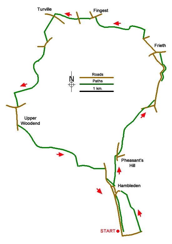
This Chilterns walk starts near Hambleden and heads north into a broad valley surrounded by rolling hills and areas of woodland. The route follows good paths and offers a worthwhile outing exploring the beautiful countryside. The walk also includes the villages of Pheasant's Hill, Frieth, Fingest, and Turville. The area has featured in many films and TV programmes.
The start is the pay and display car park (grid ref. SU785855) north of Mill End on the A4155. After parking return to the exit, turn right and take the first lane on the left. After 600 metres you reach the entrance to a pumping station on the right. Continue ahead a few metres and turn left up a bank onto a signed footpath (grid ref. SU791856). Initially the path runs along the right-hand side of a field. Continue straight across another field to a path junction. Continue ahead keeping to the left-hand side of the field. At the far end of the field bear left onto a track. After a few metres turn right onto an enclosed track and continue north ignoring a track on the right. Turn left onto the Chiltern Way and continue into Hambleden.
Pass the church on your right and then take the next right. Follow the lane round to the right and after 200 metres turn right onto a signed footpath (Chiltern Way). The path crosses meadows and then between gardens to reach a fingerpost in Pheasant's Hill (grid ref.SU783875). Turn right and continue ahead to a lane. Cross the lane and join the signed path opposite. The rising path passes through pleasant woodland continuing ahead at a path junction. Reaching a lane (grid ref. SU791888), bear right and take the first footpath on the left through a small wooden gate. Cross a field half-right to a track and Parmoor Lane.
Turn left and continue ahead at the next junction. Pass beneath trees and take the first path on the right. The path parallels the lane before re-joining it at a wide driveway. Continue ahead and take the next path on the right by a fingerpost. Take the left-hand path through a kissing gate and continue north to a road in Frieth (grid ref. SU795902). Turn left and then first right along Innings Road and continue to a junction. Take the path to the right of the gates to Glendalough and continue into Mousells Wood. Turn left at the first path junction and follow the path as it bends left to reach the edge of the trees. Turn right along a track with trees on your right. At the next junction continue ahead, again following the Chiltern Way. Continue to the road in Fingest (grid ref. SU778911).
Turn left and continue past the church on your right. Just past the church bear right to continue along the Chiltern Way. The path continues to the edge of a wood where it veers left to a gate and a lane. Go straight across and continue to the edge of Turville. Follow the path left to reach the road through this beautiful village. Cross the roads and take School Lane opposite. Pass between houses before reaching open fields. Entering the second field, leave the Chiltern Way and head half-left along a clear path that leads to Dolsden Lane (grid ref. SU765905). Ignore the path opposite and turn right to where the lane bends right.
Take the track on the bend and continue along this for just under two kilometres to a waymarked junction (grid ref. SU757891). Turn left onto Shakespeare's Way and continue to a lane. Continue ahead for 350 metres. At Upper Woodend Farm, bear left onto a signed bridleway (Shakespeare's Way). Continue along Shakespeare's Way for three kilometres to reach Skirmett Road near Hambleden. Turn right and follow the grass verge to the first path on the left. Cross a field and return to a lane. Bear left into the centre of Hambleden. Turn right and take the first path on the left across fields to return to the start.
Messaging & Social Media
Message Walking Britain and follow the latest news.

Mountain Weather
Stay safe on the mountains with detailed weather forecasts - for iOS devices or for Android devices.