Walk 1964 - printer friendly version
Abbotstone from Old Alresford Walk
Author - Lou Johnson
Length - 5.1 miles / 8.3 km
Ascent - 420 feet / 127 metres
Grade - easy
Start - OS grid reference SU588341
Lat 51.1031940 + Long -1.1615621
Postcode SO24 9DP (approx. location only)
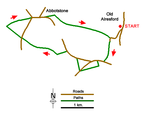
This circular walk from Old Alresford explores the downs north of the village using tracks and paths across the rolling countryside. Alresford has been famous for watercress which has been cultivated in the chalk streams. The arrival of the railway meant that the crop could be in the London markets the following morning and commercial growing boomed. This walk passes several of the cress beds.
The start is the centre of Old Alresford where parking is available near the Christy Hall and telephone box (grid ref. SU588341). After parking, and with your back to the Hall, turn right along a road beside the green. Follow the road around to the right and then left into a signed private road. Continue ahead to the end of the tarmac and take the footpath between hedges. Continue across two fields keeping to the left-hand hedge. Exit the second field and join a clear track to a lane (grid ref. SU583333).
Turn right and after 200 metres turn left onto a footpath through a gap in a hedge. Cross the lawn into a field and turn left keeping the hedge on your left. The path soon turns right and continues ahead to reach Keepers Cottage and a tarmac drive. Follow the path alongside the drive to a road (grid ref. SU577330). Cross the road and take the signed path across a field (hedge right) to a lane. Turn left along the lane (part of the Oxdrove Way). After 350 metres turn left onto a track just past a large barn. Follow the track into the valley After 250 metres you reach a junction of tracks. Bear right here and ascend gently out of the valley to a lane (grid ref. SU560339).
Cross the lane and continue ahead on rising tree lined track. After 600 metres you reach a five-way junction of paths (grid ref. SU556343) on Itchen Stoke Down. Turn right and descend to a lane. Continue ahead keeping the grassy triangle on your left. Follow the lane to the next junction at Abbotstone where you continue ahead uphill. Nearing the top of the hill, ignore the first track on the left, and then take the next track on the left (grid ref. SU566345). The track soon enters trees where the route turns right between hedges. Keep ahead on this track ignoring all tracks on the right. A final descent leads to the road used at the beginning of the walk. Follow the road around to the left and back to the start in Old Alresford.
Messaging & Social Media
Message Walking Britain and follow the latest news.

Mountain Weather
Stay safe on the mountains with detailed weather forecasts - for iOS devices or for Android devices.